the Creative Commons Attribution 4.0 License.
the Creative Commons Attribution 4.0 License.
 | 28 Mar 2023
Mackinder's “heartland” – legitimation of US foreign policy in World War II and the Cold War of the 1950s
The British geographer Halford J. Mackinder developed two different concepts of a dystopian new global order. The first, developed in 1904 and known as the pivot area concept, was adopted by German geopolitician Karl Haushofer in the 1920s. The second, developed in 1919, was named the heartland theory and was adopted in Great Britain and the USA. Haushofer reversed the dystopian vision of the pivot area concept into a utopian concept for German world power. Due to Haushofer's adaptation, interest in Mackinder's theories rose in the USA in the 1940s. Within the process of adaptation in the USA, both concepts were intertwined, resulting in the perception of the two as a monolithic bloc. Through this multi-layered process of intercontinental reception and adaptation in Germany and the USA, the term “heartland” became a generic spatial denomination detached from the geographical region it originally prescribed, integrable with various geopolitical concepts as the centre of an imagined world order. The reduction of complexity of the theory through the translation of text into maps led to its popularization among the US public during the 1940s and 1950s. Mackinder himself laid out the flexibility of the theory's interpretive possibilities by reflexively revising the theory and adapting it to the history of events over the course of the first half of the 20th century itself. In consequence, the generic spatial denomination “heartland” and the associated adopted theory served as a geopolitical argument for the strategic narrative legitimizing US foreign policy in World War II and during the Cold War.
- Article
(4178 KB) - Full-text XML
- BibTeX
- EndNote


During the session of the US Senate on 21 January 1948, Arkansas Senator James William Fulbright requested that the Marfleet lectures he had delivered at the University of Toronto on 9 and 10 December of the previous year be printed in the Congressional Record. Fulbright had spoken in Toronto about the future of Europe as a federation of states and the Western interest in a powerful Europe and addressed the Soviet Union's actions in Europe. In the lecture, he drew a line of continuity between the geopolitical goals of German geopolitician Karl Haushofer, Adolf Hitler's former deputy Rudolf Hess, and Russia's claim to power after World War II.
Let us be under no illusions. If Russia obtains control of western Europe, the control of Africa, the Near East, and the Middle East will fall into her lap like a ripe plum. She will thus be able to carry into full effect the geopolitical objectives of Haushofer and Rudolf Hess. The only difference will be that Russia – not Germany – will become the master of Europe. Russia will then control not only the heartland but the whole world island, and Europe, Asia, and Africa will become the arsenal of the Slavs. That, in rather naked terms, is the fundamental power issue which lies behind the federation of Europe. (Congressional Record, 1948a)
Which geostrategic concepts Fulbright's statement was referring to the senator did not reveal either in the speech in Toronto or in the US Senate. However, it was clear to attentive, geopolitically trained American listeners in the late 1940s that he was referring to Halford J. Mackinder's “heartland” theory, which the British geographer had developed in his book Democratic Ideals and Reality (Mackinder, 1919), when Fulbright warned that the Slavs should not dominate either the heartland or the world island, both catchphrases of Mackinder's theory. Mackinder's heartland theory had been widely discussed in daily newspapers, magazines, books, academia, courses at universities, and military academies since 1939 and had made its way into the political debate in the 1940s, as Fulbright's statement revealed (Bowman, 1942; Cobb, 1950; Strausz-Hupè, 1942; Turner, 1943; Wallace, 1942).
The analysis will show how journalists and politicians used the spatially imagined heartland to legitimize US foreign policy in the public sphere (Dalby, 1990:105–122; Fröhlich, 1998:96–105; Helmig, 2008:38; Sharp, 2000:156–168). The result will be the deconstruction of a legitimizing, geostrategic narrative that was developed primarily by US journalists in newspapers and magazines and by European immigrants in books through the conjunction of text and maps (Ó Tuathail, 1996). Following the argument by Albert et al. (2003), the heartland as a spatial imagination became part of the discursive strategy of actors in the USA to legitimize and enforce US political objectives from 1939 onwards (Albert et al., 2003:518).
First, special emphasis is given to the changes between the first version of the theory from 1904 and the second version delivered in 1919 (Mackinder, 1904, 1919). Even though both have already been explained innumerable times, some of the differences between the two versions must be pointed out (Blouet, 1987; Kearns, 2009; Ó Tuathail, 1996). What should be made clear is that Mackinder himself opened up the possibility of detaching the theory from its authorship and attachment to a particular region (Taylor, 2003:47–48). Second, it is demonstrated why and how the German geopolitician Karl Haushofer transformed Mackinder's dystopian threat scenario into the pseudo-scientific basis of a utopia of German great power and German world domination, which was crucial for the reception and adaptation of the heartland theory in the USA (Koselleck, 2018:131–149). Third, the perception, adaptation, and popularization of the heartland theory in the USA will be analysed to explain how the denomination “heartland” became generic.
3.1 The pivot area as centre of a global order
Mackinder referred in his lecture “The geographical pivot of history” to a region, which he later called heartland, as the “pivot of history” (Mackinder, 1904). The resource-rich “pivot area” was the centre of an imagined tripartite world order. The centre of the order was surrounded by the “inner or marginal crescent” and the “outer or insular crescent”. Mackinder's decision to locate the pivot area of a future global order in northern Asia was primarily due to the wealth of raw materials and the sheer size of the region. Using the potential by developing the railroad infrastructure of the region, the inhabitants could threaten the adjacent regions and the existing world order. Mackinder underpinned the choice of northern Asia by including a map that appeared in the 1904 reprint of the lecture in The Geographical Journal.
The decision to choose a cylindrical Mercator projection for the depiction of the imagined world order leads to distortions in the south and north of the globe. For that reason, the pivot area in northern Asia appears larger in a Mercator projection than it is, which leads to an overestimation of its importance within the world order in terms of the ratio of its landmass compared to other regions (Wardenga, 2012:138). At the same time, the map reduced the complexity of the concept to the division of the globe into a tripartite order of two constructed regions grouped as crescents around the pivot area. Neither the geographical argument of characterizing the pivot area as a drainage basin, showing how the rivers of the region drain into the Arctic Ocean or inland waters such as the Caspian Sea, which made it impossible to trade with the world over navigable rivers, nor Mackinder's environmentalism as a reason for the expansionary ambitions of the Asiatic peoples inhabiting the pivot area could be visualized on the map and, therefore, were missed by looking only at the map (Kearns, 2006:75, 2010:188). The extension of the pivot area was based on hydrographic parameters as well as on the settlement behaviour of the nomads (Kearns, 2009:143; Whittlesey, 1945:16–17).
In order to stigmatize the rulers of the “natural seats of power” as a threat to the existing world order in which the British Empire, despite the rapid rise of the USA and the German Empire, was still the hegemon at the beginning of the 20th century, it was necessary to project a conflict between an emerging land power in the pivot area and the British sea power, the latter of which would oppose the threatening transformation of the existing spatial order for her own ends. As Gerry Kearns has shown, in 1904 Mackinder was issuing an imperialist warning of the threats to the existing world order by a rising opponent to British trade and military hegemony (Kearns, 2009). The concentration on European history and the continents of Europe and Asia in 1904 proves that Mackinder was thinking on a transcontinental and not a global scale from a Eurocentric perspective. The USA was only seen as an ally for the British Empire by Mackinder for when it would be necessary to fight against a land power rising in the pivot area (Mackinder, 1904:436). In the pivot area concept of 1904, Mackinder tried to transmit the 19th-century political and military conflict between Great Britain and Russia in central Asia, known as the Great Game, into the hypothesis of an ongoing expansion of Asiatic peoples into Europe by referring to historical analogies to provide supporting evidence (Kearns, 2009:203). The assumption was driven by Mackinder's environmentalism, including the racial argument, that the climate and, in particular, the hydrosphere were responsible for the habit of the pivot area inhabitants to expand beyond the region they are settled in (Kearns, 2010:187–188). In that system of thought, the environment influences the physiology of men, which results in genetic habits. In the case of the Asiatic peoples of the pivot area, these habits inevitably led to conflicts with the peoples in adjacent territories. Referring to Charles Darwin, Jean-Baptiste Lamarck, and Friedrich Ratzel, Mackinder regarded ethnic communities and nations as organisms (Kearns, 2009:68). The idea of this concept is that every growing organism legitimized by natural law could replace a passing organism. In the pivot area concept, the environment was responsible for the genetically determined habit of Asiatic peoples to expand beyond the pivot area. That the conflict between Asiatic land and British sea power was inevitable by natural law, threatening the hegemony of the British Empire, was the dystopia.
3.2 A plan to reconstruct a democratic world order – Mackinder's heartland theory of 1919
Mackinder responded to the fundamental change caused by World War I by transforming the pivot area concept into a new theory which became known as heartland theory. The theory, formulated in 1919 by Mackinder in Democratic Ideals and Reality, was in many aspects different from the pivot area concept. The more historically conceived term pivot area was replaced by the organic term heartland, which represents Mackinder's notion of the world as an organism (Mackinder, 1919). The heartland theory delivered a solution for the reconstruction of Europe from a global economic and political perspective, while the pivot area concept was a clarion call for the British Empire to protect its interests against potential opponents. In the second-to-last chapter of Democratic Ideals and Reality, Mackinder projected the League of Nations as a federal organization protecting the newly established global order of fraternized self-sufficient nation states. He no longer dealt only with Eurasia but also included Africa in his considerations, coined the new term “world island”, and argued vehemently for the disintegration and reorganization of global trade instead of referring only to the interconnectedness between Europe and Asia, as he did in the The Geographical Journal pivot paper (Mackinder, 1919:151–235). For Mackinder, Democratic Ideals and Reality was a blueprint for the reconstruction of Europe and an intellectual programme worthy of recognition by the diplomats of the Paris Peace Conference (Parker, 1982:47–48). Apart from the extension of the central region of the theory by integrating Brandenburg-Prussia, Austria-Hungary, the Baltic Sea, the navigable Middle and Lower Danube, the Black Sea, Asia Minor, Armenia, Persia, Tibet, and Mongolia into the heartland, Mackinder shifted away from the fatalism of Darwinism and his environmentalist argument as causes for human habits (Mackinder, 1919:141). In Democratic Ideals and Reality, Mackinder suggested that the terms of production in an integrated global trade and ideologies were the responsible motives that led to an inevitable clash of societies, which was not caused by the German aggressor alone but by the nearly unstoppable “going concern” of both British and German societies (Mackinder, 1919:6–37).
Most important, however, was Mackinder's decision, after the experiences of World War I, to regard the Germans as the most dangerous ethnic group, whose domination of the heartland would have a devastating effect on the existing world order (Mackinder, 1919:30–1). After World War I, he rated the Prussian militarism and the idealistic–nationalistic philosophy of Johann Gottlieb Fichte as an incomparably stronger motivation for expansion than the deterministic effect of the climate on the expansionist urges of the nomads (Mackinder, 1919:14). Mackinder himself inscribed his theory with a flexibility concerning the motives for and actors of expansionism. The interchangeability of motives and actors releases the concept from its original binding to a specific group of actors and their motives for expansion. This allowed adepts of the theory to set their own parameters without compromising the overall construct of the theory.
That Mackinder in 1919 had located a southern heartland in Africa demonstrated that the geographic location of the heartland was only conditionally tied to a specific region of the world. The heartland was not as Mackinder himself suggested a geographical fact (Mackinder, 1919:143); it was a spatial imagination, which would only come to life if the potential of the geographical preconditions was deployed by men. Without the human factor, the region would remain a negligible territory. For Mackinder, the potential for a region or a greater area to become a heartland or a pivot area lay in the availability of raw materials, which were considered a prerequisite for industrialization carried out by a growing population providing the necessary labour force (Lowe, 1981:22). The southern heartland was also a drainage basin where the rivers, as in the Eurasian heartland, were not navigable to the open sea. It was inaccessible from the outside, and the mobility of the peoples was provided by mounts (Mackinder, 1919:104–7). By integrating a southern heartland in Africa into the theory and altering the boundaries of the Eurasian heartland, Mackinder himself loosened the regional ties of the heartland to northern Asia, thereby making another factor a variable that made it possible to turn potentially every region into an imagined heartland: each one a heartland in a global order representing the adepts' own perspectives.
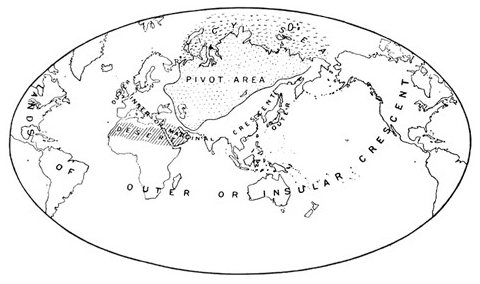
Figure 1The natural seats of power (Mackinder, 1904:435).

Figure 2World island, divided into six natural regions (equal-area projection) (Mackinder, 1919:100–101).
A crucial fact for the reception of the heartland theory was the discrepancy of the described extension of the heartland in text with the complexity-reducing maps depicting the area in Democratic Ideals and Reality. The map of the heartland as part of the world island included in Democratic Ideals and Reality did not depict the extension of the heartland area in western Europe (Fig. 2). For the observer the mapping of the western extension of the heartland is nearly the same as the pivot area in the map Mackinder used in the The Geographical Journal pivot article. Only on one of the following pages of Democratic Ideals and Reality did Mackinder show a map explicitly visualizing the extension of the heartland in the west in comparison to the pivot area. The second map was only noticed by a few recipients (Lowe, 1981) (Fig. 3).
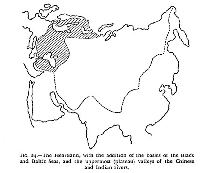
Figure 3The heartland (Mackinder, 1919:76).
Looking at the parameters of the pivot area concept and the heartland theory, it is obvious that there are crucial differences between the two systems of thought. The purposes both concepts have been written for determined the difference in their conception and outcome. The common feature of both was the geographical region as the centre of the dystopian world order. However, Mackinder himself mentioned in the preface of Democratic Ideals and Reality that the pivot area concept and the heartland theory rely on each other (Mackinder, 1919:Preface). This statement could not remain valid after having analysed the conception of both the heartland theory and the pivot area concept.
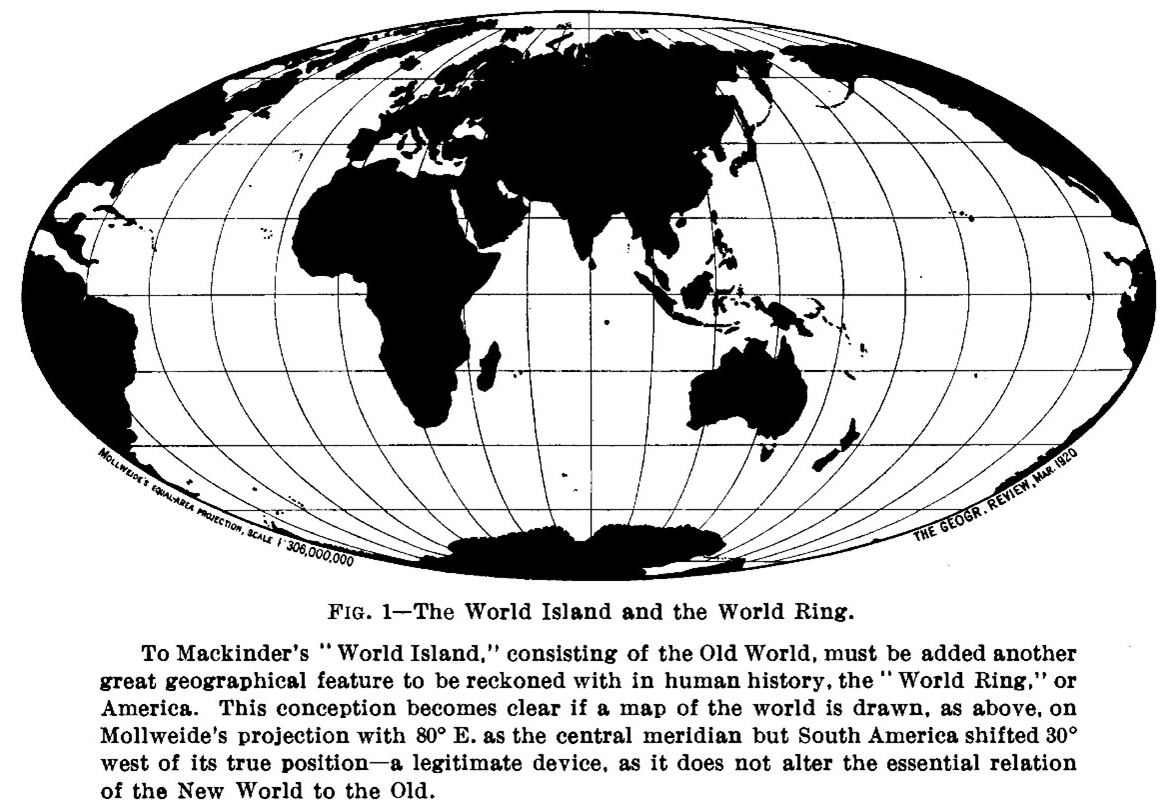
Figure 4The world island and the world ring (Dryer, 1920:206).
4.1 Democratic ideals and reality – book reviews in the USA and an adaption of the heartland theory in Great Britain
Democratic Ideals and Reality received more attention than the “geographical pivot of history” after 1904. However, Frederick J. Teggart and Charles Redway Dryer criticized Mackinder in their book reviews for his Eurocentrism and the naivety of his ideals of a federated, fraternized world community under the auspices of the League of Nations (Dryer, 1920; Teggart, 1919). Dryer invented the spatial imagination of the “world ring”, including the two Americas, the Arctic, and the Antarctic, which in the visualization of the globe in a Mollweide projection enclosed Mackinder's world island (Dryer, 1920:205–207). In Dryer's model, the world island was contained by the world ring. By using the equal-area Mollweide projection instead of the Mercator projection, Dryer adjusted the depicted extent of the heartland and the world island to the real dimensions of the region, which diminished the impression of an omnipresent heartland and world island (Fig. 4). The theory and especially the spatial imagination of the heartland were not perceived by the written text but by the map, which was a crucial factor in popularizing the imagination of the heartland.
The British geographer James Fairgrieve revised his 1915-published book Geography and World Power in 1919 according to his impressions of Democratic Ideals and Reality. He wrote a new chapter in which he applied the heartland theory (Fairgrieve and Haushofer, 1925). Fairgrieve, as one of the first adaptors of the theory, invented the idea of a North American heartland as a spatial element of an imagined circumferential “ring of land” in the Northern Hemisphere surrounding the North Pole as an interconnected landmass, where the best conditions prevailed for the settlement of men (Fairgrieve and Haushofer, 1925:338). Fairgrieve's book was translated into German by Martha Haushofer (Fairgrieve and Haushofer, 1925). Furthermore, Mackinder's 1904 article found an enthusiastic recipient in Karl Haushofer, the spouse of Martha, in the early 1920s. Haushofer stated that the geopolitical science he had devised was largely based on Mackinder's geographical pivot paper (Haushofer, 1934:76). Apart from the book review on Democratic Ideals and Reality in 1925 in the Zeitschrift für Geopolitik, Haushofer avoided calling the book a point of reference for his Geopolitik, which was coherent because of the aggressive role Mackinder ascribed to the Germans in heartland theory (Monmonier, 1995:183). For Haushofer's geopolitical thinking, the pivot area concept with its environmentalism was the point of reference. From Democratic Ideals and Reality, Haushofer concluded the review by stating that one can study how the enemy acts and learn from them (Gilbert and Parker, 1969:228).
4.2 Haushofer's utopian idea of a German-dominated Kontinentalblock
Haushofer turned the British geographer's dystopia into a utopian vision of future German autarky by projecting a continental bloc that would result from a German–Soviet–Japanese alliance, which Mackinder had cautioned against in 1904 and then even more forcefully in 1919 (Haushofer, 1941). The alliance was already in sight after the 1936 “Antikominternpakt” with Japan and the 1939 non-aggression pact with Soviet Russia were concluded. Haushofer's utopia of the alliance with the Soviet Union for the good of Germany was the reversal of the dystopian threat that Mackinder had associated with it. The continental bloc was not the precondition for conquering the world but for the possibility of creating an amphibious Eurasian land power resilient enough to resist aggression of the Anglo-American sea power by using the potential of the region, enabling under German rule a Eurasian Monroe Doctrine. For Haushofer, the continental bloc would have been the implementation of the Eurasian right of self-determination (Jacobsen, 1979:633). Haushofer's bloc combined the landmasses of the imagined German-dominated Mitteleuropa, which as a concept for regional reorganization in Europe had existed since the beginning of the 20th century (Partsch, 1904), with territories in eastern Europe claimed by the Alldeutscher Verband and Volks- und Kulturbodenforschung as part of a German-dominated cultural area, with Mackinder's pivot area bridging the gap to the Japanese realm in East Asia and the Pacific (Dostal, 2019; Haushofer, 1932). The idea of an alliance between Germany, the Soviet Union, and Japan had been mentioned by Haushofer several times already in 1913 in his book Dai Nihon (Haushofer, 1913; Sprang, 2001) but never as explicitly as in the article on the continental bloc. What Haushofer learned from Mackinder was the significance of the division of the world into spheres of interest. Haushofer adopted Mackinder's argument for the tripartite division of the world as a utopian principle for a world order from the perspective of a German nationalist.
5.1 The perception of Haushofer in the USA
The perception of Haushofer's reinterpretation of Mackinder's concept in the USA was not based on a specific article or book as it had been for the perception of the pivot area concept or the heartland theory by Haushofer himself. Four points, two of them misleadingly connecting Haushofer to the national socialist regime's foreign policy, are crucial to the reception of the heartland theory in the USA. Attention on Haushofer in the USA was determined by his reversal of the pivot area concept into a utopian concept for German domination of Eurasia seen as the intellectual base for German expansion. The second factor was the argument that Haushofer's utopian concept was based on Mackinder's heartland theory and that Americans must also learn from Mackinder as Haushofer had (Thorndike, 1942). The presumption that Haushofer's concept influenced the Lebensraum ideology and Hitler's Ostpolitik and the myth that Haushofer was the head of a geopolitical institute in Munich that provided the geopolitical expertise for the German military during the war were the two misleading factors.
The myth, cultivated in the USA, that Haushofer headed an institute for geopolitics in Munich that planned and supervised the German expansion in Europe first appeared in 1939 (Murphy, 2014; Stokes, 1939). With this myth, the controversy around Haushofer's geopolitical ideas and Mackinder's influence on these ideas began, although the foreign policy of the national socialist regime in eastern Europe was guided by other concepts. Much more crucial to the national socialist worldview of the 1940s was the thinking in terms of greater areas, as Werner Best pointed out in a contribution to the 40th-birthday commemoration of Heinrich Himmler or Carl Schmitt did in “Raum und Großraum im Völkerrecht” (Best, 1941; Schmitt, 1940; Natter, 2003), which was also a topic discussed by German geopoliticians but not connected to Mackinder's pivot area concept or heartland theory (Obst, 1940/1941). The staff of the Reichsstelle für Raumordnung was busy planning in detail the layout of towns and villages in the conquered eastern territories oriented on the work of the geographer Walter Christaller (Ó Tuathail, 1996:124; Troebs, 1937). Abstract geopolitical arguments for the establishment of a continental bloc did not play a role in the regime's plan for eastern Europe, as the primary concern was the infrastructural development of the region and the settlement of a German population. There is no evidence that the heartland theory, the pivot area concept, or Haushofer himself had a crucial influence on the national socialist regime's expansionist activities (Jacobsen, 1979:483–97).
The reference to eastern Europe and the western part of the pivot area as the first objective on the path to a German-dominated world order in Haushofer's geopolitical concept and the national socialist policies of conquest made possible the conflation of the two concepts, which in 1939 set the stage for US perceptions in understanding the heartland theory as the intellectual basis of German expansionist policy. The German–Soviet non-aggression pact of August 1939 fulfilled both Haushofer's utopia of a Eurasian continental bloc and Mackinder's fear of a union of Germans and Slavs, resulting in growing attention to German geopolitics and Mackinder's heartland theory in the USA as concepts explaining German expansionism, describing the danger of the expansion for the existing world order, and showing the need for intervention.
5.2 The German–Soviet non-aggression pact – the dawn for the reception of the heartland theory
In the year of its publication, a review of Mackinder's Democratic Ideals and Reality appeared in The Sun, which was one of the few to address the historical–philosophical dimension of the theory and also warned of the danger that existed if Germany controlled eastern Europe and the heartland (Unknown, 1919). Book reviews on Mackinder's Democratic Ideals and Reality were published in geographical journals (Dryer, 1920; Teggart, 1919). Since 1904, newspapers had mentioned and discussed the term “geopolitical” (Unknown, 1904, 1906). In 1935, Richard Hartshorne published two articles referring to German geopolitics in relation to political geography (Hartshorne, 1935a, b). Both the term heartland and the term geopolitics were known to the US public as the perception of the heartland theory and Haushofer's geopolitics accelerated after 1939.
Journalist Richard H. Stokes was one of the first to point out, in an article entitled “Russo-German entente follows path exposed by `geopolitician': Idea of Briton, Sir Halford Mackinder, traced to ears of Hitler after lying dormant for a generation” in The Evening Star on 1 October 1939, shortly after the German attack on Poland, that the German–Soviet non-aggression pact was inspired by Mackinder's heartland theory. Stokes not only discussed how Mackinder's prediction had come to pass with the German–Soviet non-aggression pact but explicitly mentioned the institute and Mackinder's influence on Haushofer and him as a source of inspiration to Hitler. Stokes interpreted Haushofer's “program for the resurrection of German world power” by creating a transcontinental bloc overthrowing Great Britain and the USA as an adaptation of Mackinder's heartland theory (Stokes, 1939).
In June 1941, Frederic Sondern Jr. published an article in Current History & Forum entitled “Hitler's Scientists: 1,000 Nazi Scientists, Technicians and Spies Are Working Under Dr. Karl Haushofer For the Third Reich”, which was reprinted in Reader's Digest in the same year. Sondern introduced himself as a “former foreign correspondent in Germany” who had reliable sources for his arguments. Sondern took up the myth of the institute already existing since 1939 and described it as a fact, which almost nobody challenged and many journalists and scientists adopted in their own articles and books (Unknown, 1939:301; Murphy, 2014:7). From that point, the heartland theory and the myth of the geopolitical institute in Munich were points of reference for the perception of German geopolitics and Mackinder in the USA.
Around that time, two books were published in English by Hermann Rauschning, who had joined the NSDAP in 1932, had been president of the Senate of the Free City of Danzig in 1933–1934, and had been expelled from the party in 1934. Rauschning emigrated to the USA via France in 1941 (Hagemann, 2018:119–32). He belonged to the first circle of recipients of German geopolitics and lectured the readers in his book The Revolution of Nihilism. Warning to the West about the importance of Haushofer and the so-called Wehrgeopolitik for the national socialist plans of domination in eastern Europe (Rauschning, 1939). Both of Rauschning's books, The Revolution of Nihilism and The Voice of Destruction (Rauschning, 1940) were repeatedly referred to by US politicians in sessions of the Senate and Congress (Congressional Record, 1941). Franz Neumann was another immigrant of the first circle, who in Behemoth discussed in detail the concepts of Lebensraum and Grossdeutsches Reich and described geopolitics as a new science under the national socialist regime that goes back to the works of Ratzel, Johan Rudolf Kjellén, Mackinder, and Haushofer (Neumann, 1942:140–50). Their analyses became the benchmark for interpreting and giving reason to the German expansion since 1939 in the USA.
The year Neumann's book Behemoth appeared, Joseph J. Thorndike asked in the 21 December 1942 issue of Life magazine what Americans could learn from Mackinder's heartland theory after the Germans, under the guidance of Haushofer, had already made it the basis of their military actions and political programme (Thorndike, 1942; Ó Tuathail, 1996:88–90). Thorndike also mentioned a geopolitical institute in Munich, headed by Haushofer, where the foundations of German expansionist policy were conceived. The article confronted the reader on the very first page with a large-scale map showing the two heartlands of the world island (Fig. 5). The orthographic map in Thorndike's article depicted the extension of the pivot area of 1904 (Fig. 1). The map, made by Richard Edes Harrison, did not depict Mackinder's heartland as described but as it was visualized in 1919, showing, on the one hand, the combination of the pivot area concept and the heartland theory into one theory and, on the other hand, that Mackinder's theory had not been studied carefully by the US map-makers, reducing it to parameters that seemed to be important for analysing Haushofer's adaptation of Mackinder's theory but not explaining the theory in depth to the public.

Figure 5The heartland (Thorndike, 1942:106–107).
On one of the following pages, a map showed the consequences of the “Air Age” for cartography, which boosted the reception of the heartland theory in the military and by politicians (Fig. 6). While the map on the first page shows the location of the world island and the heartland in an orthographic projection, the second uses an azimuthal equidistant projection centred on the North Pole to show how short the distance between the world island and the North American continent had become in the Air Age, as long-range bombers could shorten the distance between the continents by flying over the North Pole (Renner, 1942). It was only with the advent of vertical warfare in the Air Age that the technical preconditions were in place to make the heartland theory a realistic scenario to the US military and politicians, threatening the security of the Western Hemisphere, dominated by the USA, which in the map was identified as the western world, the opponent to the world island. The map also lays emphasis on Alaska and Greenland, marked as bridges where planes could stop en route between the Western and Eastern Hemispheres.
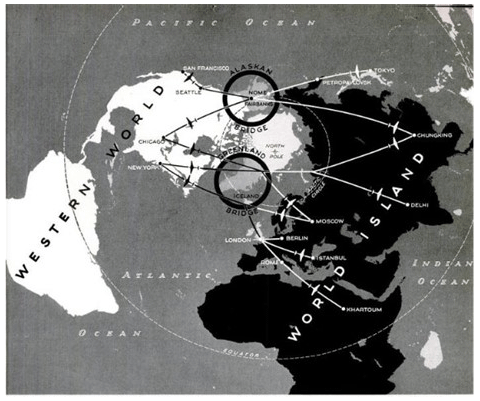
Figure 6Western world and world island (Thorndike, 1942:111).
5.3 The popularization of the heartland theory by journalists and politicians
The popular myth of the geopolitical institute was brought forward to the public in 1941 as a legitimization for the creation of the Office of the Coordinator of Information (C.O.I.), the predecessor to the Office of Strategic Services (O.S.S.), which was headed by William Joseph Donovan. Blair Bolles referred to the exemplary role of the Munich geopolitical institute for the development of US intelligence in the Evening Star of 5 October 1941, in the article “A Look at `Invisible' C.O.I.” (Bolles, 1941). The head of the agency, Donovan, became executive director of the American Committee on United Europe in the late 1940s, whose president since its founding in 1948 had been James William Fulbright. In addition, Franz Neumann's involvement with the O.S.S. shows that the intertwining between the first and the second circle of recipients occurred on an institutional level in the 1940s, which confirmed and strengthened the view by both groups of the supposed connection between the heartland theory and Haushofer's geopolitics influencing German war strategies through the Munich institute (Neumann et al., 2013).
One of the most important actors in the popularization of the heartland theory in the US public was the publisher Henry Luce, who, in addition to Life magazine, owned the magazines Time and Fortune. Life magazine, like Fortune, regularly published articles with maps discussing the heartland theory. The Fortune map “world island” from January 1943 was accompanied by a text referring to the heartland theory (Fig. 7). In the text, Harrison spoke of Mackinder's formula in Democratic Ideals and Reality and Haushofer, who “inflated the British notion of continental challenge to the oceanic empire into a grand strategy of world conquest: Who rules the seas shall be beaten by him who, by ruse and by force, commands the land masses of the world island” (Harrison, 1944). From Harrison's perspective, Haushofer's utopian concept of a continental bloc was a dystopia stopped by the US expeditionary forces. The map visualized the political conditions on the world island by colouring the Allies in red and all powers that were former neutral states or members of the Axis now occupied by the Allies, and were states that had been pro-Allies ever since, in gradations of red. With the oblique orthographic projection, the massive landmasses of the heartland and Africa visually overwhelmed the Axis powers in Europe and Japan in East Asia, showing the Soviet Union as an important ally to the USA in World War II. The Allies were shown as acting together against Japan and Germany, who were fighting two wars with the united strength of the rising new powers of Asia and North America.
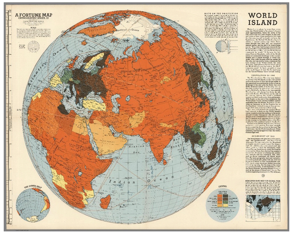
Figure 7World island (Harrison, 1943).
In the article “World View and Strategy”, which Hans W. Weigert, a German immigrant to the USA, and Richard E. Harrison wrote jointly for Compass of the World: A Symposium on Political Geography (Weigert and Harrison, 1945), the authors dealt explicitly with heartland theory, deconstructing Mackinder's 1904 map with a focus on the implications of the Mercator projection for geostrategic decision-making (Fig. 8). The authors concluded by noting “[i]t is our good luck that the military leadership in the United States has learned its lessons better and earlier than the enemy” (Weigert and Harrison, 1945:88). The map also showed only the extension of the pivot area and not even the southern heartland, with the authors deconstructing the heartland theory. The terms “pivot area” and “heartland” were used synonymously. That the military had learned a lesson from the analysis of the heartland theory is evident from the courses on geopolitics and cartography at the Naval War College in the 1950s, as well as the numerous articles in military journals, which often used maps with azimuthal equidistant projections to depict the changing strategy through the Air Age, referring to the heartland theory (Katzenbach, 1955).
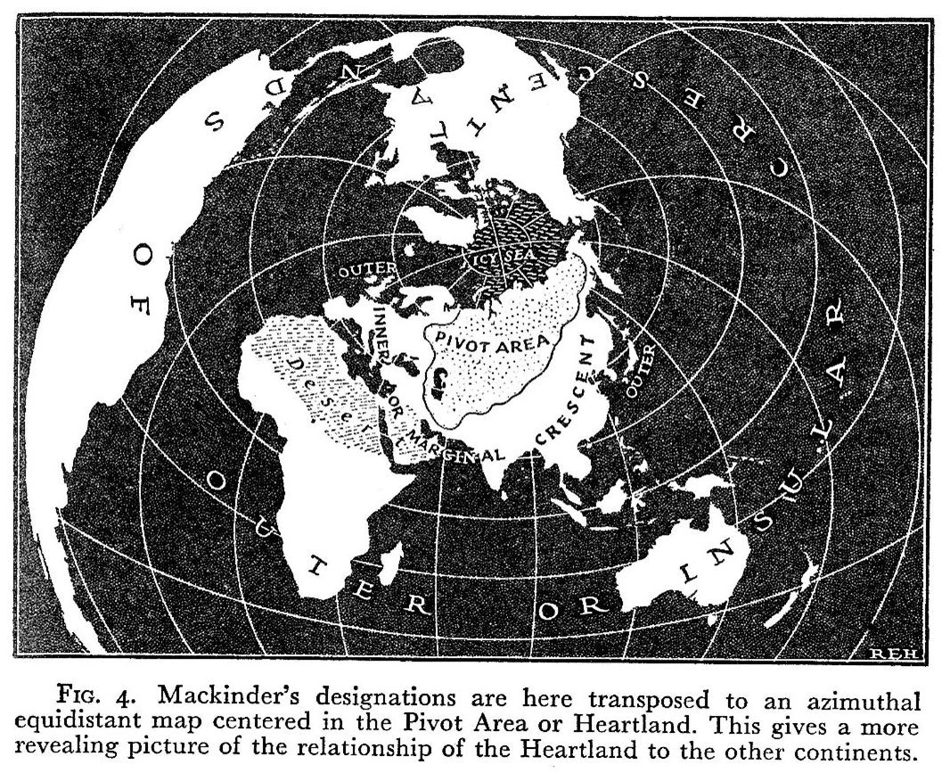
Figure 8Mackinder's heartland in an azimuthal equidistant map (Weigert and Harrison, 1945:79).
However, it was not only the cartographer Harrison, journalists such as Thorndike, scientists such as Weigert, and the military who were popularizing the heartland theory. Clare Boothe Luce, the media mogul Henry Luce's wife, had entered the House of Representatives for Connecticut's fourth electoral district (Rosenboim, 2017:76). She delivered a speech on US foreign policy on 24 June 1943, which reveals the notion of an “American heartland” and which could be attacked by Russia (Congressional Record, 1943:6340).
That there was a heartland in North America that met Mackinder's definition was brought into the US political debate by Edward Lewis Bartlett, a member of the House of Representatives from Alaska, on 18 June 1948.
Students of geopolitics have long been familiar with the teachings of Sir Halford Mackinder, who reasoned that whichever nation dominates a certain land mass (which he called the heartland) lying partly in Europe and partly in Asia, would be able eventually to control the whole world. More recent geopolitical theory speaks of two heartlands – the one designated by Mackinder, and another in North America. The shortest distance between the two `heartlands' of the world is across the Arctic regions. Our Arctic frontier has become, therefore, our primary defense consideration. Alaska, the northernmost portion of our Nation, thus assumes a place of primary importance in the strategy of national security. (Congressional Record, 1948b)
The abstraction in describing the attributes of the heartland, which Bartlett described only as “a certain land mass”, shows that the term had become detached from its attachment to a specific territory, which consequently led to the generalization of the spatial denomination heartland, and that the USA placed the North American heartland in the centre of its security and defence strategies. The defence of the North American heartland became the central motive for legitimizing military and political strategies directed against the threat to the United States from the Soviet Union in the 1950s.
In October 1945, an unknown journalist at the Detroit Evening Star suggested that the Soviet Union had embraced German geopolitics (Unknown, 1945). Three years later, the well-known columnist and book author Constantine Brown wrote in an article for the Evening Star of the defection of a former associate of Karl Haushofer, Dr. Hoffmeyer, to the services of the Soviet Union (Brown, 1948). It was conveyed to the public that Haushofer's geopolitics, based on Mackinder's heartland theory, was now also the basis of the Soviet drive for power and the expansionist urge of communism. No longer national socialist racial ideology or Prussian militarism but communism had become the ideological motive of the new aggressor against US interests, and this now threatened the North American heartland ruling already in the Eurasian heartland, an idea which had been brought forward by British geographer Charles B. Fawcett in 1933 but had not been recognized in the USA (Fawcett, 1933:282–285). Thus, the theory also became detached from its attachment to the aggressor's ideological motive for expansion. The term “heartland” emerged as a generic spatial denomination for a threat scenario that was two-sided. The Soviet Union could be portrayed to the public as an aggressor that threatened the democratic liberal world order from within the Eurasian heartland, as Mackinder had predicted in the heartland theory. The North American heartland could be built up as a counter-pole to be defended against the threat of the Soviet Union in the Western Hemisphere. The American heartland had the positive connotation of being the centre of a democratic world power protecting democracy against the autocratic rulers of the Eurasian heartland.
5.4 Nicholas Spykman's new interpretation of the heartland theory
Nicholas Spykman's well-known adaptation of the theory did not focus on Mackinder's heartland but on the region invented by himself that he named the “rimlands”, which corresponded to Mackinder's “inner and outer crescent”. Spykman used the Miller projection for his maps, which prevented distortion in the south and north of the map. The Miller projection downsized the heartland in relation to the Mercator projection and enabled Spykman to lay a greater emphasis on the rimlands. Spykman's adaptation was essential to the reception and longevity of the heartland theory, since the major wars fought by the United States in the 1950s and 1960s took place in the regions of the “rimlands”. Following the red-marked border of the heartland in Spykman's map, it is obvious that he had also not depicted the extension of the heartland but that of the pivot area (Fig. 9).
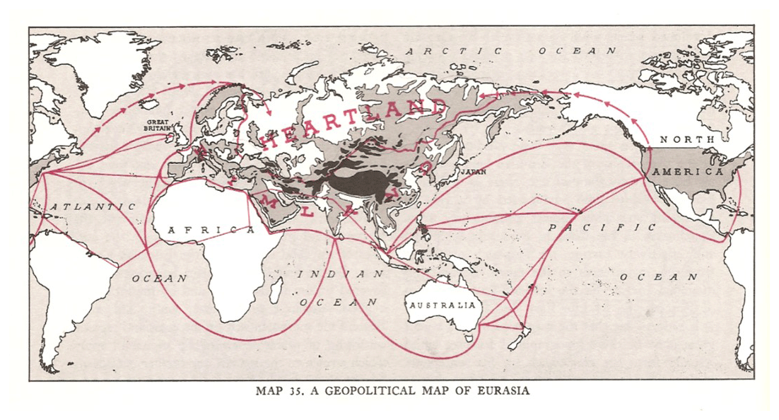
Figure 9A geopolitical map of Eurasia (Spykman and Nicholl, 1969:38).
The maps included in the paper showed the conjunction of the pivot area concept and the heartland theory as a monolithic system in US perception, which influenced the strategic narrative of US foreign policy, especially in interpreting threat scenario analyses by the military, as another map from the Military Review in an article from 1952, which quoted Spykman's map of 1944, illustrates. The extension of the heartland was almost coterminous with the state territory of the Soviet Union (Fig. 10). The once geographically defined heartland had become synonymous with a political entity and a catchphrase in the US strategic narrative. Although the founder of the containment policy George F. Kennan made no references to heartland theory or Spykman, the policy of containing communism in Korea and Vietnam could be legitimized in the public with reference to the heartland theory and Spykman because both approaches were concerned with the same region and had the same goal: to protect the democratic world against an autocratic ruler from the heartland (Fröhlich, 1998:38, 112).
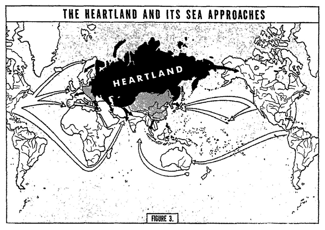
Figure 10The heartland and its sea approaches (Sokol, 1952:21).
As not only Dorothy Thompson's myriad articles on US foreign policy in the Evening Star of the 1940s and 1950s but also books such as Green Peyton's America's Heartland: The Southwest demonstrated, the term “heartland” became a generic spatial denomination within different concepts of a variety of disciplines either explaining a threat scenario for the democratic world or describing the importance of specific areas in the USA (Green, 1948; Thompson, 1956). A free-floating spatial denomination had emerged that was tied neither to a specific region nor to a motif. The fixed attributes of the heartland had been reduced: it should be a greater area with the potential for raw-material exploitation as a precondition for industrialization, containing a growing population for the purpose of industrialization and infrastructural development. All other parameters were variable and substitutable. The cartographic images and maps visualized the threat scenario, but they were limited to the representation of the geographic location and the relation of the greater area to the world, which made the theory seem not sufficiently complex; however, this allows for it to be grasped quickly and for the spread of general knowledge on the heartland theory to the public. The generalization of the spatial semantic heartland succeeded by detaching the theory from its original parameters, which Mackinder forced himself by translating it from text to a map and introducing the variability of the motifs. The generic spatial denomination “heartland” had become an element which could be employed in various utopian and dystopian geopolitical concepts, such as Aleksandr Dugin's reference to the heartland in his ultra-nationalist concept of “neo-Eurasianism” illustrated (Kearns, 2009:6). The universal spatial denomination emerged as the result of a transcontinental transfer of knowledge and processes of adaptation under different national circumstances (Frank, 2009; Helmig, 2008:16). Interpreting Haushofer's adaptation of the pivot area concept in terms of the heartland theory covers the differences between both, implying a monolithic system of thought in which the two different ideas of how to order the world became one.
The adaptation of the pivot area concept and the heartland theory showed how elements of concepts and theories could be segregated and employed in specific national and ideologically driven strategic narratives, legitimizing foreign-policy activities (Miskimmon et al., 2013). The popularization of the heartland theory in the USA established a spatial literacy among US citizens concerning the term “heartland”. The threat scenario of the theory became well known, and the term heartland represented the dystopia of the theory. References to the theory or even only to the term heartland were legitimizing arguments for US intervention in another world war and the Cold War, prohibiting a fall-back into isolationism in the face of the self-imposed responsibility of the USA as the protector of democracy against fascist, communist, and autocratic opponents (Lossau, 2001; Middell, 2021).
No data sets were used in this article.
The author has declared that there are no competing interests.
Publisher's note: Copernicus Publications remains neutral with regard to jurisdictional claims in published maps and institutional affiliations.
I want to thank René Vèron for editing the article and the reviewers whose comments helped me to strengthen the argument of the paper.
This research has been supported by the Deutsche Forschungsgemeinschaft (grant no. 433575562).
This paper was edited by René Véron and reviewed by two anonymous referees.
Albert, M., Reubner, P., and Wolkersdorfer, G.: Kritische Geopolitik, in: Theorien der Internationalen Beziehungen, edited by: Schieder, S. and Spindler, M., Leske und Budrich, Opladen, 505–529, ISBN 9783810034670, 2003.
Best, W.: Grundfragen einer deutschen Grossraum-Verwaltung, in: Festgabe für Heinrich Himmler zum 40. Geburtstag, Wittich Verlag, Darmstadt, 33–60, 1941.
Blouet, B. W.: Halford Mackinder: A Biography, A & M University Press, Texas, ISBN 9781603441988, 1987.
Bolles, B.: A look at `invisible' C.O.I. How Col. Donovan plays George Creel role explained, Evening Star, Washington, 30, https://chroniclingamerica.loc.gov/lccn/sn83045462/1941-10-05/ed-1/seq-30/#date1=1941&index=0&rows=20&words=Creel+Donovan+George+Plays&searchType=basic&sequence=0&state=&date2=1941&proxtext=Donovan+plays+George+Creel+&y=0&x=0&dateFilterType=yearRange&page=1 (last access: 10 March 2023), 5 October 1941.
Bowman, I.: Geography vs. Geopolitics, Geogr. Rev., 32, 646–658, https://doi.org/10.2307/210002, 1942.
Brown, C.: This changing world. Bale German geopolitician is reported working with Soviet staff once again, Evening Star, Washington, Section C, 3, https://chroniclingamerica.loc.gov/lccn/sn83045462/1948-10-11/ed-1/seq-9/#date1=1948&index=0&rows=20&words=Hoffmeyer&searchType=basic&sequence=0&state=&date2=1948&proxtext=Hoffmeyer&y=19&x=20&dateFilterType=yearRange&page=1 (last access: 10 March 2023), 11 October 1948.
Cobb, J. O.: The geography of the globe, Naval War College Inform., 2, 1–28, 1950.
Congressional Record: Speech by Senator Clark, Missouri, Senate, 87, 8402, https://www.congress.gov/bound-congressional-record/1941/11/01 (last access: 23 March 2023), 1 November 1941.
Congressional Record: Speech by Clare Boothe in the House of Representatives, 78th Congress, 1st session, Part 5, 89, 6340, https://congress.gov/bound-congressional-record/1943/06/24 (last access: 23 March 2023), 24 June 1943.
Congressional Record: 80th Congress, Senate, 2nd Session, Part 1, 94, 388, 21 January 1948, https://www.congress.gov/bound-congressional-record/1948/01/21/senate-section (last access: 23 March 2023), 1948a.
Congressional Record: Speech by Edward Lewis Bartlett in the House of representatives, 80th Congress, 2nd Session, Part 7, 94, House, 8825, 18 June 1948, https://www.congress.gov/bound-congressional-record/1948/06/18/house-section (last access: 23 March 2023) 1948b.
Dalby, S.: Creating the Second Cold War, Pinter Publishers, London, ISBN 0861878728, 1990.
Dostal, J. M.: Die `Zeitschrift für Geopolitik' von 1933 bis 1944: Vom eurasischen Kontinentalblock zum Zweiten Weltkrieg, J. Korean-German Assoc. Social Sci., 29, 3–46, 2019.
Dryer, C. R.: Mackinder's `world island' and its American `satellite', Geogr. Rev., 9, 205–207, 1920.
Fairgrieve, J. and Haushofer, M. (translator): Geographie und Weltmacht: Eine Einführung in die Geopolitik, Vowinckel, Berlin, 1925.
Fawcett, C. B.: A Political geography of the British Empire, University of London Press, London, 1933.
Frank, M. C.: Imaginative geography as a travelling concept. Foucault, Said and the spatial turn, Eur. J. Engl. Stud., 13, 61–77, https://doi.org/10.1080/13825570802708188, 2009.
Fröhlich, S.: Zwischen selektiver Verteidigung und globaler Eindämmung. Geostrategisches Denken in der amerikanischen Außen- und Sicherheitspolitik währen des Kalten Krieges, Nomos, Baden-Baden, ISBN 9783789053498, 1998.
Gilbert, E. W. and Parker, W. H.: Mackinder's democratic ideals and reality after fifty years, Geogr. J., 135, 228–231, https://doi.org/10.2307/1796826, 1969.
Green, P.: America's Heartland: The Southwest, Norman, University of Oklahoma Press, Norman, 1948.
Hagemann, A.: Hermann Rauschning. Ein deutsches Leben zwischen NS-Ruhm und Exil, Böhlau, Köln, ISBN 9783412511043, 2018.
Harrison, R. E.: World island, a Fortune map, Orthographic Series III, in: Fortune, https://archive.org/details/dr_world-island-a-fortune-map-orthographic-series-iii-6759000 (last access: 9 March 2023), January 1943.
Harrison, R. E.: Look at the World. A Fortune Atlas of World Strategy, A. A. Knopf, New York, 1944.
Hartshorne, R.: Recent developments in political geography I, Am. Polit. Sci. Rev., 29, 785–804, https://doi.org/10.2307/1947223, 1935a.
Hartshorne, R.: Recent developments in political geography II, Am. Polit. Sci. Rev., 29, 943–966, https://doi.org/10.2307/1947312, 1935b.
Haushofer, K.: Dai Nihon. Betrachtungen über Groß-Japans Wehrkraft, Weltstellung und Zukunft, Mittler, Berlin, 1913.
Haushofer, K. (Ed.): Jenseits der Großmächte, Teubner, Leipzig, 1932.
Haushofer, K. (Ed.): Staat, Raum und Selbstbestimmung, in: Raumüberwindende Mächte, Teubner, Leipzig, 1934.
Haushofer, K.: Der Kontinentalblock. Mitteleuropa, Eurasien, Japan, Zentralverlag der N.S.D.A.P., München, 1941.
Helmig, J.: Metaphern in geopolitischen Diskursen. Raumrepräsentationen in der Debatte um die amerikanische Raketenabwehr, VS Verlag, Wiesbaden, ISBN 9783531158310 2008.
Jacobsen, H.-A.: Karl Haushofer, Leben und Werk. Band 1. Lebensweg 1869–1948 und ausgewählte Texte zur Geopolitik, Harald Boldt Verlag, Boppard am Rhein, ISBN 9783764616489, 1979.
Katzenbach Jr., E. J.: Astigmation and geopolitics, 9 maps, Naval War College Review, 21–40, https://digital-commons.usnwc.edu/nwc-review/vol8/iss10/3/ (last access: 9 March 2023), December 1955.
Kearns, G.: Naturalising empire: Echoes of Mackinder for the next American century? Geopolitics, 11, 74–98, https://doi.org/10.1080/14650040500524095, 2006.
Kearns, G.: Geopolitics and Empire. The Legacy of Halford Mackinder, Oxford University Press, Oxford, ISBN 9780199230112, 2009.
Kearns, G.: Geography, geopolitics and empire, Trans. Inst. Brit. Geogr., 35, 187–203, 2010.
Koselleck, R.: Die Verzeitlichung der Utopie, in: Id.: Zeitschichten, Suhrkamp, Frankfurt, 131–149, ISBN 9783518292563, 2018.
Lossau, J.: Anderes Denken in der Politischen Geographie. Der Ansatz der Critical Geopolitics, in: Politische Geographie. Handlungstheoretische Ansätze und Critical Geopolitics, edited by: Reuber, P. and Wolkersdorfer, G., Universität Heidelberg Geographisches Institut, Heidelberg, 57–76, ISBN 388570112, 2001.
Lowe, J. T.: Geopolitics and War: Mackinder's Philosophy of Power, University Press of America, Washington, DC, ISBN 9780819115430, 1981.
Mackinder, H. J.: The geographical pivot of history, Geogr. J., 23, 421–444, 1904.
Mackinder, H. J.: Democratic Ideals and Reality, Holt, New York, 1919.
Middell, M.: Von Raumformaten und Raumordnungen, in: Verräumlichungsprozesse unter Globalisierungsbedingungen, edited by: Middell, M., Leipziger Universitätsverlag, Leipzig, 15–44, ISBN 9783960234180, 2021.
Miskimmon, A., O'Loughlin, B., and Roselle, L.: Strategic Narrative: Communication Power and the New World Order, Routledge, New York, ISBN 9780415717601, 2013.
Monmonier, M.: Drawing the Line: Tales of Maps and Cartocontroversy, Holt, New York, ISBN 9780805025811, 1995.
Murphy, D. T.: Hitler's Geostrategist? The myth of Karl Haushofer and the `Institut für Geopolitik', Historian, 76, 1–25, https://doi.org/10.1111/hisn.12025, 2014.
Natter, W.: Geopolitics in Germany, 1919–45, Karl Haushofer, and the Zeitschrift für Geopolitik, in: A Companion to Political Geography, edited by: Agnew, J., Mitchell, K., and Toal, G., Blackwell, London, 18–203, ISBN 9780631220312, 2003.
Neumann, F.: Behemoth: The Structure and Practice of National Socialism, Victor Gollancz Ltd., London, 1942.
Neumann, F., Marcuse, H., Kirchheimer, O., and Laudani, R. (Eds.): Secret Reports on Nazi Germany. Frankfurt School Contribution to the War Effect, Princeton University Press, Princeton, ISBN 9780691134130, 2013.
Obst, E.: Due Grossraum-Idee in der Vergangenheit und als tragender politischer Gedanke der Zeit, Wintersemester 1940/41, Wilhelm Gottl. Verlag, Breslaus, Bundesarchiv Koblenz, N1122/113, 1940/1941.
Ó Tuathail, G.: Critical Geopolitics: The Politics of Writing Global Space, University of Minnesota Press, Minneapolis, ISBN 9780415157001, 1996.
Parker, W. H.: Mackinder: Geography as an aid to statecraft, Oxford University Press, Oxford, ISBN 9780198232353, 1982.
Partsch, J.: Mitteleuropa, Die Länder und Völker von den Westalpen und dem Balkan bis an den Kanal and das Kurische Haff, Perthes, Gotha, 1904.
Rauschning, H.: Revolution of Nihilism: Warning to the West, Alliance Book Cooperation, New York, 1939.
Rauschning, H.: Gespräche mit Hitler, Europa Verlag, Zürich, 1940.
Renner, G. T.: Human Geography in the Air Age (A text for high school students), Macmillan, New York, ISBN 9780267801831, 1942.
Rosenboim, O.: The Emergence of Globalism: Visions of World Order in Britain and the United States, 1939–1950, Princeton University Press, Princeton, ISBN 9780691168722, 2017.
Schmitt, C.: Raum und Grossraum in Völkerrecht, Zeitschrift für Völkerrecht, 22, 145–79, 1940.
Sharp, J. P.: Condensing the Cold War: Reader's Digest and the American Identity, University of Minneapolis Press, Minneapolis, ISBN 9780816634156, 2000.
Sokol, A. E.: Sea power in the next war, Militar. Rev., 32, 11–26, 1952.
Sprang, C. W.: Karl Haushofer und Japan. Der Einfluss der Kontinentalblocktheorie auf die Japanpolitik des `Dritten Reichs', in: Geschichte, Geistesgeschichte/Religionen, Gesellschaft, Politik, Recht, Wirtschaft, Band 2, 11. Deutschsprachiger Japanologentag in Trier, edited by: Gössmann, H. and Mrugalla, A., LIT, Münster, 121–134, ISBN 9783862050406, 2001.
Spykman, N. J. and Nicholl, H. R.: The Geography of the Peace, in: New Edn., Archon Books, Hamden, Conn., ISBN 9780208006547, 1969.
Stokes, R. H.: Russo–German entente follows path exposed by `geopolitician'. Idea of Briton, Sir Halford Mackinder, traced to ears of Hitler after lying dormant for a generation, Evening Star, Washington, Section C, 3, https://chroniclingamerica.loc.gov/lccn/sn83045462/1939-10-01/ed-1/seq-39/#date1=1939&index=0&rows=20&words=Mackinder&searchType=basic&sequence=0&state=&date2=1939&proxtext=Mackinder&y=0&x=0&dateFilterType=yearRange&page=1 (last access: 10 March 2023), 1 October 1939.
Strausz-Hupè, R.: Geopolitics: The Struggle for Space and Power, Putnams, New York, 1942.
Taylor, P. J.: Radical political geographies, in: A Companion to Political Geography, edited by: Agnew, J., Mitchell, K., and Toal, G., Blackwell, London, 47–58, ISBN 9780631220312, 2003.
Teggart, F. J.: Geography as an aid to statecraft: An appreciation of Mackinder's `Democratic Ideals and Reality', Geogr. Rev., 8, 227–242, https://doi.org/10.2307/207838, 1919.
Thompson, D.: How Russia got in Middle East: Columnist in 1945 predicted alienation of Arab world open gates to Reds, Evening Star, Washington, 15, https://chroniclingamerica.loc.gov/lccn/sn83045462/1956-11-12/ed-1/seq-15/#date1=1956&index=2&rows=20&words=heartland&searchType=basic&sequence=0&state=&date2=1956&proxtext=Heartland&y=0&x=0&dateFilterType=yearRange&page=1 (last access: 10 March 2023), 12 November 1956.
Thorndike, J. J.: Geopolitics: The lurid career of a scientific system which a Briton invented, the Germans used and Americans need to study, in: Life, 106–115, https://books.google.de/books?id=NVEEAAAAMBAJ&pg=PA106&hl=de&source=gbs_toc_r&cad=2#v=onepage&q&f=false (last access: 9 March 2023), 21 December 1942.
Troebs, K.: Nationalsozialistische Raumpolitik, in: Reichsstelle für Raumplanung, Öffentlichkeitsarbeit, Presse, Propaganda, Innen- und außenpolitische Zielsetzungen für die Raumordnung, Karl, Troebs, Leiter der Pressestelle der Reichsstelle für Raumordnung und der Reichsplanungsgemeinschaft e. V., 2 organigrams, Bundesarchiv Koblenz, 9 pp., R 113/2113M, 1937.
Turner, R.: Technology and geopolitics, Militar. Affair., 7, 5–15, https://doi.org/10.2307/1982989, 1943.
Unknown: Points of view, St. Louis Republic, St. Louis, 6, https://chroniclingamerica.loc.gov/lccn/sn84020274/1904-05-09/ed-1/seq-6/#date1=1904&index=2&rows=20&words=geo-political&searchType=basic&sequence=0&state=&date2=1904&proxtext=geopolitic&y=0&x=0&dateFilterType=yearRange&page=1 (last access: 10 March 2023), 9 May 1904.
Unknown: Foreign comment for and against simplified spelling. England's enemies oppose simplified spelling, The Fairmont, West Virginia, 8, https://chroniclingamerica.loc.gov/lccn/sn86092557/1906-09-18/ed-1/seq-3/#date1=190&index=0&rows=20&words=geopolitical&searchType=basic&sequence=0&state=&date2=1906&proxtext=geopolitic&y=8&x=9&dateFilterType=yearRange&page=1 (last access: 10 March 2023), 18 September 1906.
Unknown: Sublimated geography, The Sun, Section 6, 10, https://chroniclingamerica.loc.gov/lccn/sn83030431/1919-06-01/ed-1/seq-64/#date1=1919&index=0&rows=20&words=Heartland&searchType=basic&sequence=0&state=&date2=1919&proxtext=Heartland&y=0&x=0&dateFilterType=yearRange&page=1 (last access: 10 March 2023), 1 June 1919.
Unknown: Hitler's World Revolution, the New Statesman and Nation, 301, 26 August 1939.
Unknown: 5th District GOP warned of Reds, Detroit Evening Times, Section C, 4, https://chroniclingamerica.loc.gov/lccn/sn88063294/1945-12-19/ed-1/seq-4/#date1=1945&index=10&rows=20&words=geopolitical&searchType=basic&sequence=0&state=&date2=1945&proxtext=geopolitic&y=17&x=6&dateFilterType=yearRange&page=1 (last access: 10 March 2023), 19 December 1945.
Wallace, H.: New path to freedom: An American concept of a postwar world. Contrast it with Hitler's scheme of a Nazi's `new order' of universal slavery, Evening Star, Washington, Section E, 2, https://chroniclingamerica.loc.gov/lccn/sn83045462/1942-12-27/ed-1/seq-70/#date1=1942&index=0&rows=20&words=heartland&searchType=basic&sequence=0&state=&date2=1942&proxtext=Heartland&y=0&x=0&dateFilterType=yearRange&page=1 (last access: 10 March 2023), 27 December 1942.
Wardenga, U.: Kartenkonstruktion und Kartengebrauch im Spannungsfeld von Kartentheorie und Kartenkritik, in: Räumliche Orientierung, Karen und Geoinformation im Unterricht, edited by: Hüttermann, A., Kirchner, P., Schuller, S., and Drieling, K., Westermann, Braunschweig, 134–143, ISBN 9783141428018, 2012.
Weigert, H. and Harrison R. E.: World View and Strategy, in: Compass of the World, edited by: Weigert, H, Stefansson, V., and Harrison, R. E., Macmillan, New York, 74–88, 1945.
Whittlesey, D.: The horizon of geography, Ann. Assoc. Am. Geogr., 35, 1–36, https://doi.org/10.2307/2560985, 1945.
- Abstract
- Introduction
- Structure of the argument
- Two systems of thought – Mackinder's pivot area concept and the heartland theory
- The perception and adaptations of the heartland theory in Great Britain, the USA, and Germany
- The popularization of the heartland theory in the USA
- Conclusion
- Data availability
- Competing interests
- Disclaimer
- Acknowledgements
- Financial support
- Review statement
- References