the Creative Commons Attribution 4.0 License.
the Creative Commons Attribution 4.0 License.
 | 24 Jan 2023
Applying Friedrich Ratzel's political and biogeography to the debate on natural borders in the Italian context (1880–1920)
Matteo Proto
This paper examines the contribution of Italian academic geography to the processes of nation-building between ca. 1880–1920. With reference to Friedrich Ratzel's works, it explores the ways in which biological and vitalist theories shaped political processes. In the decades between Italy's national unification until the first post-war period, Italian academic geographers helped to consolidate the nation-state by means of theoretical reflection, applied research, and education. The main focus of geographers was in defining the national space and its boundaries, especially by developing a scientific analysis that could establish the exact position of the terrestrial border along the Alpine chain. The scientific topic was strongly connected with the nationalist question of irredenta, which garnered growing consideration in the last 2 decades of the 19th century. The epistemological turn in Italian geography was particularly influenced by new approaches in German geography introduced by scholars such as Oscar Peschel and Friedrich Ratzel and aimed to formulate a general understanding of biogeography in its relationship with the earth's physical space. The reception of this theoretical model in the political debate and the way it was applied in the following decades proved highly significant.
- Article
(3044 KB) - Full-text XML
- BibTeX
- EndNote


In the decades between Italy's national unification (1861) and the first post-war period, Italian academic geographers helped to consolidate the nation-state by means of education, applied research, and theoretical reflection. The focus of geographers was in defining the national space and its boundaries, especially in searching a correspondence between the political ambition of a border along the Alpine chain and a scientific analysis that could establish the exact position of this border. As underlined by Atkinson (2000), the geographical imagination of Italy has a long tradition that proved fundamental in the country history. Since the first half of the 19th century geographical surveys and tools such as maps, atlases, and statistical works had played a significant role in sustaining political discourses of national identity and nation-building processes (Pecout, 2002; Ferretti, 2022). Focusing on the post-unification period, this paper aims to compare the Italian debate on the Alpine border with the coeval scientific–geographical ideas that developed in Western thought more broadly and, more specifically, with the theoretical advancement of German geography, with references to the vitalist and biogeographical formulations in the field of human geography promoted by Friedrich Ratzel among others. The analysis begins by placing the Italian geographical debate in the historical context of late 19th century Italy, characterized by the emergence of radical, aggressive nationalist ideas in the framework of a reactionary and vitalist understanding of modernism.
In doing so, I set my research in three main thematic frameworks that lie at the heart of the vitalist and nationalist project. The first aspect regards the relation between nation-building, nationalism, and the development of geographical ideas, with reference to the identification of natural/geographical regions and borders. A significant body of research conducted in the field of historical geography had stressed the bond between geographical knowledge development, nation-building, and civic education in different national contexts, beginning with Charles Withers' (2001) works on Scotland and Hans Dietrich Schulz's (2005) on Germany. After the consolidation of modern national territorial states in Europe, governmental politics required a set of geographical tools to understand spatial dynamics and to improve land control techniques which were built through tools of territorial management applied both inside and outside the boundaries of the state (Elden, 2013). For Italian geographers in late 19th century, the main task was to produce a body of studies and representations (surface calculation, reliefs, topographical maps, etc.) that would enable the government to operate in its internal space, and, at the same time, they were called on to define the line delimiting the state. These practices were intended to consolidate the body of the state and to nationalize its internal space, by managing land, controlling the population, and tracing and patrolling the external border. Having achieved this objective, it would then be possible to pursue a policy of expanding the state outside of both its national borders and Europe more broadly. In the Italian case, the first step in such internal consolidation was to complete the national political space, the soil of the fatherland, also by finding a scientific explanation for resorting to war.
More recently and with a specific focus on map production and their impact on politics and diplomacy, Steven Seegel (2018) has stressed the role of academic geographers and their biographical background in the making of (Eastern) European and world geography as a transnational history that involved scholars from both sides of the Atlantic. This issue leads us to the second thematic aspect that focuses on the professionalization of geography: a process that occurred both in Italy and internationally at the turn of the century, based on a combination of the general progression of scientific thought and the empirical findings of domestic and overseas geographical exploration. In addition to colonial expeditions, the exploration/colonization of the internal space of the nation-state was equally important. In the Italian case, such internal exploration is well exemplified by the practice of alpinism in the sense of the scientific and bourgeois conquest of mountains that reached its peak with the First World War and that was well sustained by academic geographers (Armiero, 2011). Indeed, this period was also characterized by the growth of geographical debate at the international level. Congresses, field trips, and peace conferences encouraged encounters among different actors, and the participants created and consolidated networks that fostered the circulation of geographical publications and ideas (Meusburger et al., 2010). As we will see, also Italian geographers were involved in this cooperative network that put in connection European and North American scholars. While Seegel put map production and dissemination at the core of his inquiry, this paper focuses mainly on the development, circulation, and re-elaboration of research methodologies and theoretical frameworks in the field of biogeography, regional geography, and political geography, through the analysis of Italian scientific publications. Secondary archive sources spread further light onto the circulation and reception of geographical ideas. The analysed historical period is comprised between the last 2 decades of the 19th century – when, following Italian unification of 1861, a political and scientific debate emerged concerning the competition of the national state – and the end of WWI – as this very national project was achieved through the overlapping of the imagined community of the nation-state with the supposed natural space of the country. Key figures in this process were geographers Giovanni and Olinto Marinelli who, at the turn of the century, radically renovated the Italian geographical tradition projecting it into European and North American mainstream scientific debates and establishing, through their cohort, a long-lasting school of thought (Proto, 2014).
Beyond the individual biographical dimension and the transnational networks of knowledge in contributing to shape geographical ideas, the non-human dimension also played a key role in this development. This relates to the third issue discussed here: on one hand, to the role played by non-human agency in informing geographical research and on the other hand, the naturalization of the society produced by academic geography in considering nature as something related to human action and governmental practices. In this view, natural laws were used to explain the functioning of human society and therefore to inspire political goals. The move to postulate a natural condition in society entailed a significant progression in Western thought and political praxis, a development that, Michael Foucault argued, gave rise to the mechanism of biopolitics (Lemke, 2010). Engaging the recent discussion surrounding the English translation of Friedrich Ratzel's essay Der Lebensraum (Bhambry, 2018), the article also reflects on the way biological and vitalist theories helped shape the analysis of political processes and, specifically, the political–geographical construction of the Italian terrestrial border along the Alps.
This paper aims at contributing to the debate on the circulation and reception of geographical ideas and on their role in shaping the political space. On the one hand, it provides evidence of the Italian case study that, while unexplored to date, represents an important example of geographical imagination and political process in the age of European imperialism, particularly concerning the role played by geographers in the making of the nation, as already analysed in different contexts (Seegel, 2018; Gorny, 2022). On the other hand, by investigating a specific theoretical reflection on regional partition and bordering, it offers a significant example of border theory that could be relevant beyond the Italian case. In this sense, the contribution speaks also to the field of border studies as it moves beyond a geopolitical imaginary and reinterprets bordering practices as part of a biopolitical regime aimed at naturalizing certain partitions and building identities as well as at developing violent policies of segregation and racialization (see e.g. Vaughan-Williams, 2009).
2.1 Nationalist modernism and the establishment of Italian academic geography
In the second half of the 19th century, the development of geography in Italy was conditioned by a particular political context. Having emerged and been consolidated in the wake of the Risorgimento, liberal democratic institutions were still vulnerable at this time, threatened as they were by conflicting political movements. The new Italian kingdom was burdened by numerous issues that jeopardized the formation of a bourgeois liberal ruling class. On the one hand, as emphasized already by Gramsci (1975), the perpetuation of feudal–corporative power structures conditioned and impeded the country's modernization. On the other hand, the industrial revolution began significantly later in Italy than in other European states and so was inconsistent and incomplete (Gentile, 2009). Given the weakness of the liberal bourgeoisie, alternative modernizing political forces arose, which attributed Italian cultural and technological backwardness to the inefficiency of the liberal political class. In addition to the newly established Italian Socialist Party (1884), with its republican and antisystem leanings, other political bodies appeared that were both antithetical to the socialists and opposed to the liberal ruling class, such as the Pro Patria (founded in 1885), the Lega nazionale (1891), and the Associazione Nazionalista Italiana (1910), which promoted a radical understanding of nationalism by defending the preservation and the spread of Italian language and culture, in contrast to other similar associations that had been established abroad, especially in the German lands (Gentile, 2003). Italian nationalist movements drew more support since the last 2 decades of the 19th century with the emerging political issue of the terre irredente (unredeemed lands) and the related political phenomenon of irredentism. The toponym terre irredente included the regions of Trento, Trieste, the Istrian Peninsula, and Dalmatia, still under Austro-Hungarian rule, which were considered to share a common cultural heritage and language with the Italian fatherland but which had been placed outside the borders of Italy by the 1861 unification (Cattaruzza, 2016).
Italian nationalism was also nourished by modernist literary and artistic movements such as the avant-garde movement of Futurism and the intellectual figure of Gabriele D'Annunzio (1863–1938) which were characterized by a belief in technology and progress and which aimed to merge the ideal of industrial modernity and scientific–technological with the nationalist myth. Perfectly aware of Italy's lack of power in the international context, Futurist artists and theorists bounded up the process to modernize the country with a glorification of war as an instrument for promoting the idea of a creative destructive process with the power to transform and improve reality while also bringing about technological progress (the myth of the machine–war machine as a vital force improving human potential) and nationalism (Gentile, 2003; see also Berghaus, 1996).
Which is the relation between this political, socio-cultural context and the emerging and consolidation of geographical ideas in the academy? In fact, at the same time and at the heart of geographical inquiry was the idea that nature is constantly transforming, whether that was terrestrial morphology at the large scale or the forms, diffusion, and distribution of living species at smaller scales. These reflections were stimulated, on the one hand, by the newly formulated evolutionary theories that had radically overhauled scientists' understanding of life and, on the other hand, by research in geophysics and geomorphology which shed light on the dynamic processes of landscape formation. As I will show, geographers paralleled Italian modernist and nationalist intellectuals in believing that the causes of war lay in the physical nature of the world and in the competitive dynamics of biological life. Not by chance and in line with the above ultra-nationalist cultural–political framework, most Italian geographers adhered to a nationalist and reactionary ideology that was sceptical of liberal democracy and parliamentarism, a position which, later, drove them to wholesale acceptance of the Fascist regime (Gambi, 1994). There were only a few notable exceptions, such as the anti-colonialist geographer Arcangelo Ghisleri (1855–1938), a political thinker and activist who condemned any form of aggressive nationalism against other European nationalities as well as the colonial politics of conquest and domination in overseas countries (Ferretti, 2016). But for the vast majority, the connection between biological evolutionism, developments in physical geography, and the rise of nationalism were fuelled by the uptake of strongly positivist approaches, in which geography's theories and methodologies were borrowed from the life and earth sciences even in application to human geography.
The late 19th century was characterized by a wholesale reorganization of academic knowledge, following national unification, that also involved geography thanks to the foundation of the Italian Geographical Society and the implementation of university chairs in geography, which were more than doubled (going from 7 in 1880 to 20 in 1894). In the context of academic geography, Giovanni Marinelli (1846–1900) and his son Olinto (1876–1926) can be regarded as the leading actors in establishing modern geographical thinking (Proto, 2014). Thanks to their national and international relationships, these two scholars introduced and disseminated significant geographical ideas that proved fundamental to conditioning the development of the discipline for many decades. The Marinellis, father and son, held the chair in geography at the University of Florence (the main hub of scientific positivism in Italy at the time) for 34 years and spearheaded a school of thought that shaped the theoretical evolution of geography in almost every Italian university. Their geographical understanding was closely caught up with evolutionistic frameworks and by “borrowing” the methodologies of the life sciences to study human processes. As the following sections show, this “pure science” approach concealed significant political implications. As several scholars have emphasized, the overarching influence of Charles Darwin's and Alfred Russel Wallace's evolutionary frameworks meant that the fields of biogeography and human/political geography which emerged in the second half of the 19th century shared many similarities in terms of their theoretical–methodological approaches, and both served as instruments of expansionism and imperial dominion (Moore, 2005; Chiantera Stutte, 2018). Giovanni Marinelli introduced Darwin's theories into Italian geography as early as 1879 by stressing the significance of the English scientist's chorological method, and this new framing made it possible to reconceive geography as a unified discipline within the natural sciences and with geology in particular, a view consistent with the principles of Darwinism (Marinelli, 1879). As stated by Marinelli, geography had to be understood both as mother and daughter to geology:
It is the Mother in methodology, because it is the geographical phenomena which explain the geological ones. It is the daughter in the matter, because geological phenomena originate the geographical ones. This is because Geology is the Geography of the past, just as Geography is the Geology of the present. (Marinelli, 1879:36)
In commemorating Darwin's demise in 1882, Marinelli reiterated the connection between Darwinism postulations and an understanding of geography as a chorological study and aimed to investigate terrestrial phenomena, both natural and anthropic, by describing their distribution over space and time, making possible to reconsider geography as a natural science:
Geography established itself with the studies in maritime deep abysses, in moving transparencies of the atmosphere, on the vast deserts, on the elevated mountaintops. In one word, in the thousand varieties which characterize the terrestrial morphology. Finally, geography established itself in the great synthesis with which it inclusively collects what other sciences investigated. (Marinelli, 1882:1120)
His son Olinto would also implement evolutionary approaches in geography. Olinto was educated in the positivist cultural environment of the University of Florence, where he was influenced by several figures including the Anglo-Italian biologist Enrico Hillyer Giglioli (1845–1909). Educated in London under the guidance of Charles Lyell, Giglioli had merged his interests in explorations, anthropology, and geography to carry out significant research in biogeography (Proto, 2014).
Besides Darwinism and the life sciences, another fundamental pillar in the development of Italian geographical discourse was its relationship with the earth sciences. While most of the academic geographers of the time were educated in the humanities, Olinto Marinelli opted to focus on the field of the earth sciences, with a specific interest in geology, also graduating with a dissertation about the morphology of the eastern Alps (Marinelli, 1902a). His theoretical approach was more and more oriented towards this perspective, and his hegemonic role in the academy led the majority of Italian scholars to follow suit. William Morris Davis, whose theory on the geographical cycle was taken up by most Italian geographers, also played a significant role in fostering the connection between geography and the earth sciences well beyond Italy but with a significant impact on the circulation of geographical ideas in a transnational perspective (Clout, 2004). Olinto Marinelli had a close relationship with him and, in 1912, took part in the Transcontinental Excursion of the American Geographical Society promoted by Davis. It was on this occasion that Marinelli unequivocally recognized the validity of Davis' morphological theory: as he writes in his memoirs, he became convinced through discussion and conversation with the other participants and especially by observing the erosion phenomena taking place in the vast American surfaces under Davis' mentorship (Marinelli, 1914). This understanding of the morphogenesis of the landscape was fundamental to explaining the inorganic process of spatial transformation, a process complementary to and intertwined with the sphere of organic life.
2.2 The reception of German language geography in Italy: Oscar Peschel and Friedrich Ratzel
In addition to the above-mentioned influence of ideas connected to evolutionism and Anglo-American geomorphology, the foundation of modern Italian geography was strongly dependent from the circulation of geographical theories produced by German language geography, the most relevant geographical school in 19th century Europe. The influence of German geographers on Italian sciences dominated the whole century, starting with the reception of Alexander von Humboldt's ideas in many fields of knowledge. While Humboldt's books received various translations in Italian, the work of the other protagonist of German geography in the first half of the century, Carl Ritter, was less acknowledged with almost no translations, despite his thought being significantly influenced some Italian geographers such as Giuseppe Dalla Vedova (1834–1919) and Bartolomeo Malfatti (1828–1892).
Since he was a young schoolteacher and before becoming a university professor, Giovanni Marinelli had appreciated the works of German geographers. Born in Udine in the region of Friuli, Marinelli was already an adult when his homeland left the Austro-Hungarian Empire to join the Italian Kingdom in 1866. Therefore, in his teaching and research activities he could take advantage of German works about the Alps and the Italian (former Austrian) northeast, while Italian literature on these regions was still modest (Proto, 2014). In the late 1880s, he discussed in Italian geographical journals the debate occurring at the time in Germany between Ritter's historical and teleological approach and new approaches introduced by positivist geographers such as Alexander Supan, Alfred Kirchhoff, and Oscar Peschel (Marinelli, 1893). Regarding Marinelli, the comparative approach advanced by Peschel (1870) in his Neue Probleme der vergleichenden Erdkunde helped to investigate the distribution and the interaction between geographical phenomena, both physical and anthropic, thus reinforcing the chorological approach. Geography had to investigate, on one hand, the morphology, meaning the exterior form of geographical elements and phenomena. On the other hand, it had to analyse and describe their distribution on the earth's surface to come to the chorological description. In this perspective geography was a descriptive discipline, with no reference to the investigation of causal and nomothetic laws which could have explain the origins of geographical elements and phenomena, but was limited, on the contrary, to determine their external form and their position in the space. In sum, Marinelli stated that a geographical survey had to answer the questions come (how) and dove (where) (Marinelli, 1879).
As stated before, Marinelli's geographical investigation not only was circumscribed to the physical world of rocks, soils, and other inorganic elements but also contemplated the biological sphere, thus posing a biogeographical issue that considered the earth as the scenario for plants and animal life, including human beings. This required engaging with a set of historical, social, and cultural questions. From this, an anthropogeographical issue originated in Italian geographical thought that aimed to develop a positivist science of anthropogeography, well beyond – as Marinelli polemically observed – the metaphysical and teleological approach that had negatively conditioned Carl Ritter's geography (Marinelli, 1893).
The Italian epistemological turn thus took advantage from new approaches developed in German geography by Peschel and later by Friedrich Ratzel and aimed to formulate a general understanding of biogeography in its relationship with the earth's physical space. It was Peschel who had coined the term Lebensraum (living space), a concept subsequently developed and made popular by Ratzel, to indicate a certain natural region in which a specific population increased and expanded (Klinke and Bassin, 2018). According to Ratzel's further explanation of the concept, the main scientific issue was to identify the relationship between a stable and finite terrestrial space and dynamic life that continuously evolved by enlarging – or reducing – its space of diffusion. This interaction between terrestrial surface stability and the mutation of life represented the core vitalist dynamic that scientists evoked to describe a Lebensraum (Barua, 2018). Therefore, it was morphological and organicist dynamics that were believed to define the space in which life spread and grew. In so doing, Ratzel developed an example of biopolitical theory in which political space corresponded to a given natural order and was therefore the manifestation of natural laws (Klinke, 2019). Ratzel's understanding then suggested that a correct political strategy should acknowledge and follow the laws explaining the transformation of terrestrial morphology and life forms, in order to develop a territorial politics to reinforce and expand the state (Chiantera Stutte, 2018).
The reception of Peschel's and Ratzel's theorization, already introduced by Giovanni Marinelli in the last decades of the 19th century, is well situated in the reflections of Marinelli's son Olinto, who at the beginning of the new century contributed to defining a theoretical and empirical framework aimed to advance a unified understanding of geography. Since then, with the name of geografia integrale (integral geography) Italian geographers found a new paradigm to explain biogeography in its relationship with the physical space of the earth, which despite being anchored to a neutral positivist understanding of science, became a powerful instrument for the strengthening of state politics, as we will see.
As stated by Olinto Marinelli, the aim of this new integral geographical paradigm was to contribute to the study of humanity in understanding its origins, present state, and future development perspectives. Like geology, geography had to be examined through the analysis of the present conditions, the causes, and the processes of its transformation, thus reconstructing the evolution of the physical and organic word, including the moral sphere of human beings. Not by chance – Olinto Marinelli argued – Ratzel had placed anthropogeography as the last chapter of his biogeography. Developing what his own father had postulated, for Marinelli geographical research began as a descriptive knowledge. Starting from the investigation of a local dimension and developing a survey at the regional scale, geography had to analyse the distribution of phenomena and stress through comparison with their interaction or – as Marinelli defined it – their associazione (association) (Marinelli, 1902b). In reading Ratzel's theorization, Marinelli accepted the German geographer's principle of consistency of the terrestrial space and of all the related terrestrial elements, which implicated that each phenomenon reflected the very same laws governing the earth. This allowed for inferring comparable elements from regional analysis and, thanks to the comparative methodology developed by Peschel, to abstract them from their local contest in order to postulate general laws (Marinelli, 1905a).
In this framework, it is significant to parallel some concepts developed by Marinelli with Ratzel's theorization. Regarding Marinelli the possibility of deducing general theorizations from the regional survey was bounded to the above-mentioned concept of associazione. The definition of phenomenal associations was what allowed geography to establish causal explanations as well as general laws and, therefore, to become a true science. The principle of association explained therefore a dependency relation between both physical and biological phenomena and corresponded to what Marinelli, by translating Ratzel's concept of Lage (location/situation), defines as sito (location) or situazione (situation). In Ratzel's anthropogeography the Lage represents a geographical condition that, well before the Raum (space), is fundamental to understand the relation between physical geography and biogeography, which means the relation between the earth and humanity (Marinelli, 1905a; see also Ratzel, 1891).
This socio-environmental relation is then understood as unfolding along a predetermined course of development directed by natural laws. Therefore, history, as well as the relationship between populations and political entities, finds its explanation in geography and, specifically, both in its physical and biological dimension. In reality, Marinelli rejected Ratzel's complex philosophy of history on the grounds that it was too misleading and impossible to explain through scientific perspectives, but he appreciated the German geographer's methodological approach. From this approach he inferred the supposition that human beings are not overpowered by environmental conditions but that there is instead a kind of balance between the inorganic forces of nature and the organic forms of life. This balance, furthermore, can be explained by the laws of nature and by taking the research methodologies of the natural and life sciences and applying them to the investigation of social phenomena. Unlike Ratzel, Marinelli did not posit an explicit monist explanation, although he did view organic and inorganic life as essentially united (Marinelli, 1905a, 1908).
Thanks to these theoretical and methodological shifts, Italian geography as driven by the Marinellis superseded the kind of classical geographical thought which prevailed in Italy until the third quarter of the 19th century and was still characterized by the insights of German geographers Humboldt and Ritter and by the development of statistical research. Its main concern lay in positing the concordance between specific populations and their “natural” regions of reference. In pre-unification Italy, statistical studies had been specifically aimed at identifying the correspondence between scientifically determined spaces and the distribution of the population (Gambi, 1973). Research products such as statistical monographs and educational and popular works including maps and atlases had played a significant role in forming the national consciousness of the emerging bourgeoisie through a supposedly “neutral” scientific investigation (Pecout, 2002; Farinelli, 2018).
In contrast, by rejecting any reference to an historical situated understanding of socio-natural relationships, the Marinellis' new positivist paradigm made a significant break with the past. Despite never calling into question their understanding of science as neutral and objective, Italian geographers adhered to strictly nationalist discourses – such as the idea that the Italian culture and people had an innate civilizing role – which were unrelated to scientific explanation and instead stemmed from the ultra-nationalist and colonialist context characterizing the turn of the century. This nationalistic approach can be seen most clearly in the move to establish a political geographical perspective that conditioned the rise and development of regional studies and their associated spatial categories. More specifically, it was this approach that led geographers to apply these theoretical spatial models to understanding nation-state territoriality, the national space, and its borders.
3.1 Regional geography and geographical borders
As stated before, the political issue of the terre irredente was the key question motivating nationalist theories and sentiment in the last decades of the 19th century, and it would be the main issue conditioning Italy's subsequent involvement in the First World War. Regarding Italian irredentism, two main threads can be identified in the multifaceted debate about the unredeemed lands: an extremist nationalist position that called for the widest possible expansion of Italian national space and moderate, democratic positions that took into consideration the non-Italian population living in the border regions and thus advocated for political solutions based on autonomy and self-determination (Cattaruzza, 2016). Debates over this national political claim were also evident in the process employed by Italian geographers to define the nation's borders. By the late 19th century, as Giovanni Marinelli was questioning the physical–geographical border of Italy, this issue remained unresolved in both scientific and political debate. Risorgimento literary and political rhetoric – from Giuseppe Mazzini to Giosuè Carducci – had identified the Alpine chain of mountains as the natural boundary of the fatherland. Yet the Alps, Europe's largest mountain chain, did not present an easy topographical basis to political territoriality. Even more complicated than the area's morphology was its ethnic–linguistic character: this, as well as questions of political sovereignty, divided the Alpine region among different bordering countries: France, Switzerland, Italy, Germany, and the Austro-Hungarian Empire.
Giovanni Marinelli began investigating the border while he was involved in a research project aimed at calculating the exact surface area of Italy's national space. For this process, he needed a clear element of reference from which to start the calculation. This project was part of the move to impose statistical surveying and governmental control over the newly unified state. Keenly aware as he was of the mutability of natural life, Marinelli came to the decision to posit the Alpine watershed – the imaginary line dividing the different hydrographical basins – as the boundary of the Italian natural region (Marinelli, 1883). In this, he was not particularly innovative: identifying hydrographical basins as natural regions and, more broadly, recognizing natural regions on the basis of their political significance had been widespread practice in geographical thought since the early modern period (Farinelli, 2018). In this case, however, the identification of this border had significant political consequences since, defined in this way, the Italian natural region included considerable portions of land under Swiss and Austrian rule. For Italian scholars, the task then became one of developing a theory that could tie the physical–morphological aspects together with the biological and social ones, which would scientifically establish the extension of the national territory.
It was then Olinto Marinelli who could finally develop a general theory in the field of regional geography to infer a scientific definition of the border and to frame the theory of the Alpine watershed as a border in a broader reflection on geographical partitions. Regarding Marinelli, the scientific recognition of a border was the consequence of the definition of a natural or, better said, geographical region. Linear borders, therefore, came after the identification and the representation of a specific region. This theorization was outlined during a lectio magistralis that Marinelli held in the autumn of 1915, a few months after Italy had entered the war. The lecture, later published as a scientific article, represents a summary of the research Marinelli carried out by building on and refining the fruits of his father's scientific work over the last 20 years. During the speech and paralleling Ratzel, Marinelli tried also to postulate a geographical explanation of the causes of conflicts in general and specifically of the Great War as the possible outcome of comparative research on the physical and anthropic conditions of different regions, thus evoking the irredenta issue and finding a scientific explanation for resorting to war. Based on a complex project of collecting and analysing geographical elements and phenomena, Marinelli coined the concept of regione integrale (integral region) as the outcome of geographical surveying and a synthetic description of the humanity–environment relationship. He conceptualized the integral region as a geographical unity based on multiple, overlapping analytical layers of geographical research, from geomorphology and physical geography to bio- and human geography. The identification of regional units proceeded through a multilevel analysis starting from the so-called regione elementare (elemental region), characterized by the diffusion of a single geographical element or phenomenon (e.g. plant, animal, climate variable). The further step was represented by the regione complessa (complex region) resulting from the aggregation of distinct associated elements or phenomena and thus defining climatic regions, zoogeographic regions, ethnographic regions, etc. until the final level of the regione integrale as the outcome and overlapping of the different analysed physical and biological elements and phenomena (Marinelli, 1916). The systematic process of defining an integral region was therefore a scientific method with the power to produce an authentic regional study – not simply a statistical synopsis or a descriptive representation but a chorographical work that could provide a general idea of each land “in terms of its natural conditions, as well as the human ones that more or less depend on the natural ones” (Marinelli, 1916:6). Precisely because it offered an exhaustive explanation of the socio-natural relationship and encompassed social quantifiable factors as well, the scientific model of the integral region could easily be used to define the relationship between a specific population and its space of diffusion, i.e. to identify the spatial extent of a national community in the same way as Ratzel's concept of Lebensraum. In sum, an integral region could correspond to a nation-state or at least to the current spatial distribution of a national community, as stated in this excerpt from Giuseppe Ricchieri, Marinelli's close friend with whom he had joined Davis' American excursion in 1912:
When all the geographical elements and phenomena, both the physical ones and the historical and anthropic – especially those determining the complex human aggregation of the nation – coexist over a land that is separated from other border lands, this land has to be regarded as an integral region. Very few countries on the earth deserve this definition such as Italy. (Ricchieri, 1920:7)
An integral region was therefore the scientific definition of the nation-state extension, and, if analysed in a comparative perspective, such chorographical descriptions could also speak to the causes of war, by stressing the dissimilarity between actual political partitions and the proper scientific recognition of the territorial state.
As we will see, the Italian integral region identified by academic geographers through their scientific inquiry could help to highlight the differences with the coeval spatial extension of the Italian state, thus also speaking to the causes of war. Moreover, having outlined the criteria to identify a region, it was then necessary to investigate the border of such defined geographical unities. The necessity to identify a proper linear border of the integral region pushed Marinelli to develop the conceptualization of the so-called geographical border, another theoretical apparatus that was fundamental to demonstrating the role of geographical research in identifying the reasons behind conflicts. In Marinelli's theorization, the geographical border was deduced from regional investigation and had to be located in a defining morphological element such as a river, sea, or a big mountain chain such as the Alps. What made such a morphological element a defining one was the fact that it caused a significant decrease in the characteristics by which the region itself was identified. In his Politische Geographie, Ratzel had argued that it was impossible to scientifically determine linear borders because it had been demonstrated that regional characteristics never end all at once; rather they tend to appear less and less frequently in a progressive decrease from the centre of the region to its periphery. According to this perspective, the only things that could be identified via scientific analysis were boundary belts, areas of varying size in which regional characteristics gradually diminished (Ratzel, 1897). In theorizing living space, Ratzel focused on the constant mutation of the relationship between life and the physical character of the terrestrial space – between bio- and geo- – that caused the Lebensraum to change (Barua, 2018). Marinelli turned the question on its head: he drew on what he had learned from Davis to focus on the permanence and stability of terrestrial surfaces, elements such as the ridge lines of mountain chains that are less intensively affected and transformed by the morphogenic processes of the geographical cycle (Davis, 1899). In examining the continuing transformation of the earth, Marinelli considered not only organic life but also inorganic forces and the way they interacted with the biological sphere by analysing morphological limits and related boundaries. His engagement with Austrian physical geographer Eduard Richter's (1847–1905) theorization was also fundamental in relation to this aspect. Richter had conducted significant research regarding the altitude limits of snow, flora, and fauna, and Marinelli, believing that all inorganic and organic elements could be analysed using same morphogenic and organicist explanatory framework, applied Richter's findings to his own inquiry into regions and regional borders (Marinelli, 1905b). In this synthesis of the organic and inorganic, morphological processes were understood as part of terrestrial life as a whole.
Marinelli was thus able to validate the scientific process of jumping from a natural border to a geographical border because, in his thinking, geographical borders were determined not merely by physical–natural (e.g. morphological) factors but by a complex of chorographic descriptions that analysed and synthesized all the regional geographical elements (integrating human ones as well) into a framework based on scientific laws. Including cultural and socio-economic factors in this explanation did not entail considering historically, culturally, and socially situated processes through which an area had evolved but simply retained those elements that could be located and mapped, i.e. analysed and represented through cartography (Marinelli, 1916; see also Farinelli, 2018).
3.2 The spread of geographical ideas
To clarify this process in an empirical perspective, identifying an integral region and its geographical borders allowed scholars to scientifically define how the land ought to be partitioned. When these geographical partitions diverged from the political ones of the time, geography could demonstrate the legitimate reasons for insisting that the borders be redrawn, including by resorting to war. Several Italian geographers became involved in empirically demonstrating Marinelli's theoretical hypothesis by applying his model to the Italian context. The applied study of the Alpine border and unredeemed regions were obviously particularly significant, and between 1914 and 1919 these areas were subjected to numerous monographic and cartographic studies, some scientific and others caught up with civic education and propaganda. Situated in the contest of academic debate were for example the publications of geographers such as Carlo Errera (1915) or Attilio Mori (1916), both stressing the correspondence between the Alpine watershed and Italy's geographical border and the substantial overlapping between the Italian physical region and the spread of the Italian ethnolinguistic community. In so doing, they denied the existence of the non-Italian population south of the Alpine ridge, thereby extending the Italian national space to also include some areas hosting substantial or even majority German or Slovenian and Croatian populations. Such popularized scientific issues were also the topic of public speeches delivered by academic geographers in front of the military troops that were fighting to achieve the right border for the fatherland, during the Great War (see e.g. Musoni, 1917).
The geographical models produced by the academy spread also in civil society by means of educational books, atlases, popular magazines, and guidebooks. A significant example is the publication of a series of educational atlases supported by the publisher Giovanni De Agostini and aimed to popularize the geography of the three unredeemed lands: Trentino-South Tyrol (Battisti, 1915; see also Proto, 2016), Dalmatia (Dainelli, 1918), and Istria (Battisti, 1920). All these works presented a geo-historical overview of these lands, including the physical geography, demography, and economics, and adopted the model of Marinelli's integral region to illustrate to a broader public the geographical unity of these regions and their historical, geographical, and cultural bonds with Italy (see also Proto, 2017; Dai Pra and Gabellieri, 2021). As we can see in Fig. 1, maps contributed to stress this bond, also by practically applying and demonstrating Marinelli's multiple layer regional analysis through different cartographies – physical, historical, ethnographical, economical, etc. – which finally, through their juxtaposition, led to the concept of an integral region or geographical unity.

Figure 1Example of regional comparative research in Istria regarding ethnical distribution (left panel) and soil exploitation (right panel). Source maps courtesy of the library of the Department of History and Cultures, University of Bologna.
The scientific theorization of the geographical border revealed its relevance also after the end of the war, when the victorious powers were going to draft the new map of Europe. Marinelli had hitherto avoided any direct involvement in the political debate, but in the occasion of the Paris Peace Conference, he contributed to support the Italian claims with a scientific publication edited in 1919. This paper (Marinelli, 1919), complete with a map (Fig. 2), appeared in English in the Geographical Review. Marinelli chose this journal not only because of his relationship with the American geographical community but also because it was the flagship journal of the American Geographical Society, at that time directed by Isaiah Bowman, who was also serving as chief territorial specialist with the American delegation at the Paris Peace Conference (Smith, 2003). In analysing the multicultural and multilingual regions along the Alpine chain, Marinelli asserted that these regions were to be understood as the result of centuries of invasion: on one hand, such incursions had destroyed the geographical unity of these areas; on the other, they had given rise to improper political borders not in line with the geographical ones. As we can see in Fig. 2 there was a significant discrepancy between the ethnographic–linguistic distribution of the population depicted in colours and the geographical border represented by the thick black line of the Alpine watershed. Instead, argued Marinelli, scientifically determined soil conditions and regional partitions could define the geographical units in this area and indicate their borders so the space could be repartitioned properly. Studies in diplomacy and politics also adopted this scientific repartitioning. In this article and in other published studies, Italian geographers took part in an international debate involving the different national geographical schools, a debate that was also entangled with the coeval political and diplomatic dispute that had arisen at the Paris Peace Conference around the idea of drafting a post-war map of Europe (Seegel, 2018).
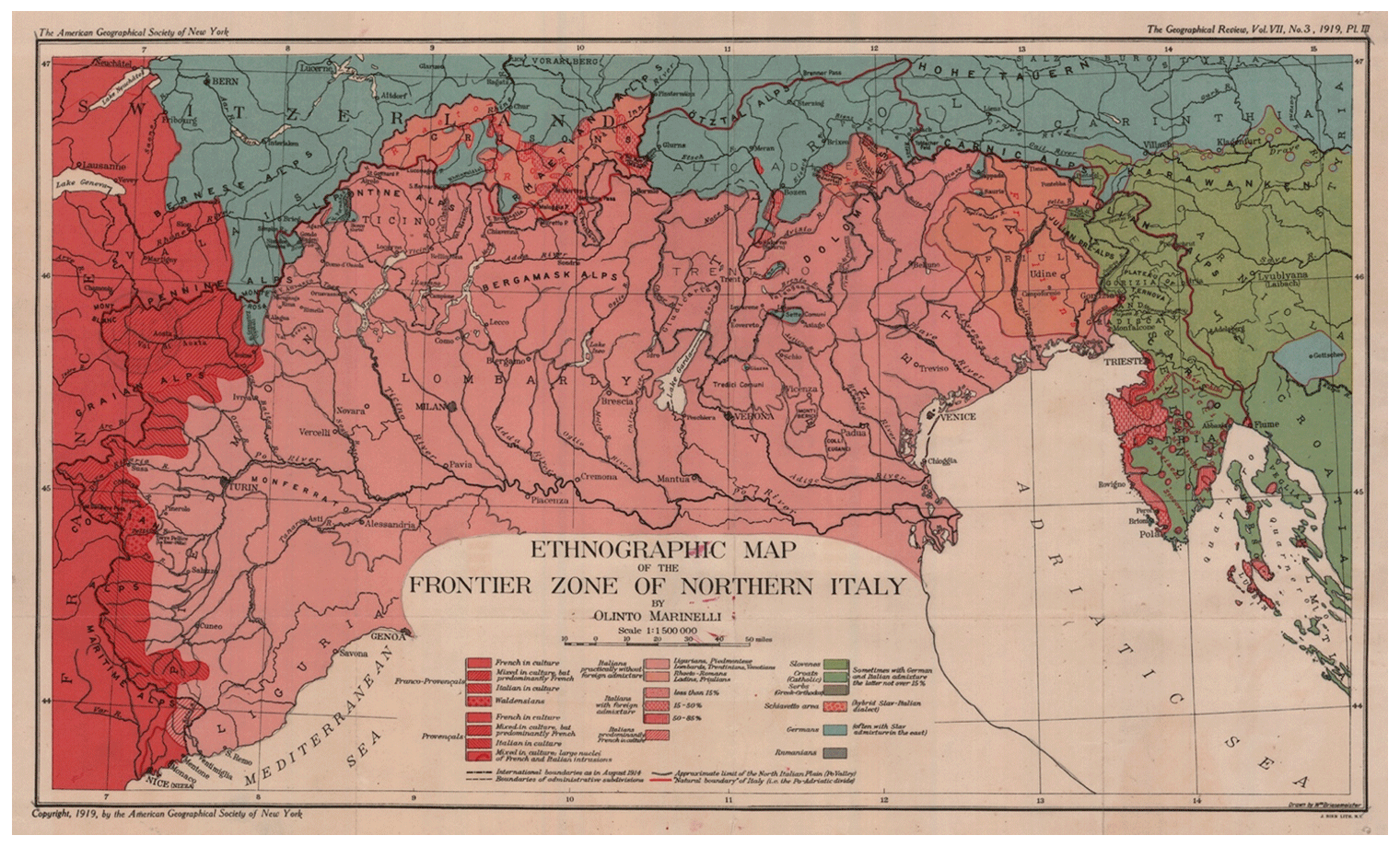
Figure 2Olinto Marinelli's map on the ethnogeography of northern Italy. Source map courtesy of the library of the Department of History and Cultures, University of Bologna.
To grasp how Marinelli's model was received outside of Italy, we can look to an excerpt from John McFarlane's (1873–1953) presidential address at the British Association for the Advancement of Science meeting in 1920. In this address, McFarlane reported that
The long and as yet unsettled controversy of the limits of the Italian Kingdom illustrates very well the difficulties … in the determination of national boundaries. The annexation of the Alto Adige [South Tyrol] has been generally accepted as inevitable. It is true that the population is German, but here, as in Bohemia, geographical conditions appear to speak the final word. (McFarlane, 1920:110–111)
The international impact of Marinelli's work is also evidenced by a letter written by Bowman to Richard Hartshorne in 1934 in which, referring to Marinelli's English article and the map published 15 years before, he stated
Marinelli … wrote one highly important paper which he sent to the Geographical Review and which was published in the March number, 1919. This material arrived at the Peace Conference in time to produce a marked impression upon the American delegation.1
Of course, the theoretical and empirical developments in Italian geography were not proposed in isolation; many European geographers were involved in questioning natural and political borders in the same period, including in relation with the unstable geographies of the war and post-war order. A significant example was the coeval debate in French geography about the eastern national border along the river Rhine, a debate that involved key figures in the discipline such as Paul Vidal de la Blache (Heffernan, 2001). The German language geography vision was thoroughly outlined by the work of Albrecht Penk (1916), which clashed with the position asserted by Italian geography. British geographers also took part in the discussion about internal European borders. For example, Marion Newbigin (1920) incorporated Italian geographical theorization about the border into her work, accepting the Italian claim over the Alpine border. Moreover, British and American geographers played a significant role in shaping the new political map of Central-Eastern Europe (Seegel, 2018; Győri and Withers, 2019).
In the Italian case, the reception of geographical model in the public debate and the way it was applied in the following decades proved highly significant. While Italian geography still claimed the role of a neutral and depoliticized form of knowledge, the theorization set up by the Marinellis produced a wholesale politicization of scientific discourse that led most of the scholars to support the politics of the state and its power dynamics. In this process, the socio-natural relation was indeed very significant in shaping Italian geographers' understanding of nature–society relation. On the one hand, this was bound with the practices of contemplating the natural world: Giovanni Marinelli's theory on mountain chains and geographical boundaries was substantially informed by the alpinism he had practised since he was young, and, as mentioned above, Olinto ended up adopting Davis's idea of the geographical cycle thanks to his observation of the morphology of American plateaus. On the other hand, the representational models synthesizing the geographers' physical–biological research were implied to explain all the different features of terrestrial life, even the political ones. The lesson of Ratzel's Lebensraum had promoted an understating of politics, in which the political space corresponded to a given, natural order as well as politics had to be understood as the outcome of natural imperatives (Chiantera Stutte, 2018). Like Ratzel (see also Klinke, 2019), Olinto Marinelli framed the question of war in a way that eliminated any references to state rationales, social practices, ideologies, etc. to present war as a necessity rooted in the natural world. War viewed as a natural and vital transformation was “only world health” to quote the definition coined by Futurist intellectuals, and indeed this convergent viewpoint illustrates the parallel between geographical thought and reactionary, modernist literary and artistic avant-gardes.
The naturalization of the state promoted through geographical theories proved to be effective also in the post-war scenario, through the intense and violent Italianization policies implemented in the former unredeemed land also with the contribution of academic geographers and characterized for a biopolitical control of ethnical minorities. This also led to racialized and racist theorizations in Italian geographical works (Gambi, 1994; Proto, 2022). At the same time, academic geographers were involved in applying their regional models for enlarging the space of Italian influence to the point of achieving a kind of Italian eastern space, later supporting the imperial ambitions of the Fascist regime and feeding the aggressive politics that drove the country into the Second World War.
No data sets were used in this article.
The author has declared that there are no competing interests.
Publisher's note: Copernicus Publications remains neutral with regard to jurisdictional claims in published maps and institutional affiliations.
I would like to thank Charles Withers for his support and suggestions during my visit at the University of Edinburgh and for his comments to a previous version of this paper. I would also thank the editor Benedikt Korf and the three anonymous reviewers for their comments and suggestions. Finally, I thank Francesco Buscemi for helpful suggestions on drafts of this article.
This paper was edited by Benedikt Korf and reviewed by three anonymous referees.
Armiero, M.: A rugged nation: mountains and the making of modern Italy, The Withe Horse Press, ISBN 9781874267645, 2011.
Atkinson, D.: Geopolitical imaginations in modern Italy, in: Geopolitical Traditions: Critical Histories of a Century of Geopolitical Thought, edited by: Dodds, K. and Atkinson, D., Routledge, 93–117, ISBN 9780415172486, 2000.
Barua, M.: Ratzel's biogeography: a more-than-human encounter, J. Hist. Geogr., 61, 102–108, https://doi.org/10.1016/j.jhg.2018.05.015, 2018.
Battisti, C.: Il Trentino. Cenni geografici, storici, economici con un'appendice sull'Alto Adige, Istituto Geografico De Agostini, 1915.
Battisti, C.: La Venezia Giulia: cenni geografico-statistici, Istituto Geografico De Agostini, 1920.
Berghaus, G.: Futurism and politics between Anarchist Rebellion and Fascist reaction, 1909–1944, Berghahn, ISBN 1571818677, 1996.
Bhambry, T.: F. Ratzel, Lebensraum: a biogeographical study, J. Hist. Geogr., 61, 59–80, https://doi.org/10.1016/j.jhg.2018.03.001, 2018.
Cattaruzza, M.: Italy and Its Eastern Border, 1866–2016, Routledge, ISBN 9781138791749, 2016.
Chiantera Stutte, P.: Ratzel's stone guest: The art of politics in the work of Friedrich Ratzel, J. Hist. Geogr., 61, 91–96, https://doi.org/10.1016/j.jhg.2018.04.009, 2018.
Clout, H.: Lessons from experience: French geographers and the transcontinental excursion of 1912, Prog. Hum. Geogr., 28, 597–618, https://doi.org/10.1191/0309132504ph507oa, 2004.
Dainelli, G.: La Dalmazia: cenni geografici e statistici, Istituto Geografico De Agostini, 1918.
Dai Pra, E. and Gabellieri, N.: Bridging geographical research and political action: the Trentino Italian region in the scientific and socialist writings of Cesare Battisti, 1895–1914, J. Hist. Geor., 71, 83–93, https://doi.org/10.1016/j.jhg.2021.01.005, 2021.
Davis, W. M.: The geographical cycle, Geogr. J., 14, 481–504, 1899.
Elden, S.: The birth of territory, The University of Chicago Press, ISBN 0226202577, 2013.
Errera, C.: Il confine fra Italia e Austria, Istituto Geografico De Agostini, 1915.
Ferretti, F.: Arcangelo Ghisleri and the “Right to Barbarity”: Geography and Anti-colonialism in Italy in the Age of Empire (1875–1914), Antipode, 48, 563–583, https://doi.org/10.1111/anti.12206, 2016.
Farinelli, F.: Blinding Polyphemus: Geography and the Models of the World, Seagull, ISBN 9780857423788, 2018.
Ferretti, F.: Geographies of Federalism during the Italian Risorgimento, 1796–1900, Palgrave Macmillan, London, ISBN 9783030961169, 2022.
Gambi, L.: Una geografia per la storia, Einaudi, ISBN 8806037129, 1973.
Gambi, L.: Geography and imperialism in Italy: From the “Unity” of the nation to the “New” Roman Empire, in: Geography and empire, edited by: Godlewska, A. and Smith, N., Blackwell, 74–91, ISBN 0631193855, 1994.
Gentile, E.: The Struggle for Modernity: Nationalism, Futurism, and Fascism, Praeger, ISBN 0275976920, 2003.
Gentile, E.: La Grande Italia: the myth of the nation in the twentieth century, University of Wisconsin Press, ISBN 9780299228101, 2009.
Gorny, M.: Drawing Fatherlands. Geographers and Borders in Inter-war Europe, Brill, ISBN 9783506708830, 2022.
Gramsci. A.: Quaderni dal carcere, in: Vol. 5, Il Risorgimento, Editori Riuniti, ISBN 9788835991892, 1975.
Győri, R. and Withers, C.: Trianon and its aftermath: British geography and the `dismemberment' of Hungary, c.1915–c.1922, Scott. Geogr. J., 135, 68–97, https://doi.org/10.1080/14702541.2019.1668049, 2019.
Heffernan, M.: History, Geography and the French National Space: The Question of Alsace-Lorraine, 1914–18, Space Polity, 5, 27–48, https://doi.org/10.1080/13562570120049645, 2001.
Klinke, I., Vitalist temptations: Life, earth and the nature of war, Polit. Geogr., 72, 1–9, https://doi.org/10.1016/j.polgeo.2019.03.004, 2019.
Klinke, I. and Bassin, M.: Introduction: Lebensraum and its discontents, J. Hist. Geogr., 61, 53–58, https://doi.org/10.1016/j.jhg.2018.05.019, 2018.
Lemke, T.: From state biology to the government of life: Historical dimensions and contemporary perspectives of `biopolitics', J. Classic. Sociol., 10, 421–438, https://doi.org/10.1177/1468795X10385183, 2010.
Marinelli, G.: Della geografia scientifica e di alcuni suoi nessi collo sviluppo degli studi astronomici e geologici, Bollettino della Società Geografica Italiana, 16, 195–235, 1879.
Marinelli, G.: Carlo Roberto Darwin e la Geografia, Atti del Regio Istituto Veneto di Scienze, Lettere ed Arti, 8, VIII, 1279–1321, 1882.
Marinelli, G.: L'area del Regno d'Italia, Bollettino della Società Geografica Italiana, 15, 241–268, 1883.
Marinelli, G.: Concetto e limiti della Geografia, Rivista Geografica Italiana, 1, 6–32, 1893.
Marinelli, O.: Descrizione geologica dei dintorni di Tarcento, Carnesecchi, 1902a.
Marinelli, O.: Alcune questioni relative al moderno indirizzo della Geografia, Rivista Geografica Italiana, 9, 217–40, 1902b.
Marinelli, O.: Federico Ratzel e la sua opera geografica, Rivista Geografica Italiana, 12, 8–18, 102–126, 1905a.
Marinelli, O.: L'opera geografica di Edoardo Richter, Rivista Geografica Italiana, 12, 274–283, 351–368, 1905b.
Marinelli, O.: Del moderno sviluppo della geografia fisica e della morfologia terrestre, Rivista Geografica Italiana, 15, 226–248, 1908.
Marinelli, O.: Un viaggio di istruzione negli Stati Uniti d'America (L'escursione transcontinentale), Ricci, 1914.
Marinelli, O.: La geografia in Italia. Discorso di Olinto Marinelli con alcune appendici, Rivista Geografica Italiana, 23, 1–24, 113–131, 1916.
Marinelli, O.: The Regions of Mixed Population in Northern Italy, Geogr. Rev., 7, 129–148, 1919.
McFarlane, J.: Address to the Geographical Section, in: Report of the Eighty-Eighth Meeting, British Association for the Advancement of Science, 98–113, 1920.
Meusburger, P., Livingstone, D., and Jöns, H. (Eds.): Geographies of Science, Springer, Heidelberg, ISBN 9789048186105, 2010.
Moore, J.: Revolution of the Space Invaders: Darwin and Wallace on the Geography of Life, in: Geography and Revolution, edited by: Livingstone, D. and Withers, C., Chicago University Press, Chicago, 106–132, ISBN 0226487334, 2005.
Mori, A.: Il confine orientale d'Italia, Bollettino della sezione fiorentina del Club Alpino Italiano, 7, 2–27, 1916.
Musoni, F.: Cause ed aspetti, specialmente geografici, dell'odierno conflitto europeo, Rivista Geografica Italiana, 23, 111–131, 1917.
Newbigin, M.: Aftermath: A geographical study of the peace terms, Johnston, 1920.
Pecout, G.: La carta d'Italia nella pedagogia politica del Risorgimento, in: Immagini della nazione nell'Italia del Risorgimento, edited by: Banti, A. and Bizzocchi, C., Carocci, 69–87, ISBN 884302096, 2002.
Penk, A.: Die Österreichischen Alpengrenze, Engelhorns, 1916.
Peschel, O.: Neue Probleme der Vergleichenden Erdkunde als Versuch einer Morphologie der Erdoberflache, Dunker & Humelot, 1870.
Proto, M.: Giovanni Marinelli (1846–1900) and Olinto Marinelli (1874–1926), in: Geographers: Biobibliographical Studies, 33, edited by: Lorimer, H. and Withers, C., Bloomsbury, 69–105, ISBN 9781472566614, 2014.
Proto, M.: Geografie e cartografie di guerra: “Il Trentino. Cenni geografici, storici, economici. Con un'appendice sull'Alto Adige” di Cesare Battisti (1915), Storicamente, 11, 1–19, https://doi.org/10.12977/stor617, 2016.
Proto, M.: Irredenta on the map: Cesare Battisti and Trentino-Alto Adige cartographies, J.-Reading, 2, 85–94, https://doi.org/10.4458/9446-07, 2017.
Proto, M.: Italian geographers and the origins of a quantitative revolution: from natural science to applied economic geography, in: Recalibrating the Quantitative Revolution in Geography. Travels, Networks, Translations, edited by: Gyuris, F., Michel, B., and Paulus, K., Routledge, 165–179, ISBN 9780367640866, 2022.
Ratzel, F.: Anthropogeographie, Engelhorn, Stuttgart, 1891.
Ratzel, F.: Politische Geographie, Oldenbourg, München, 1897.
Ricchieri, G.: Il concetto di regioni e di confini nella sistematica geografica, Zanichelli, Bologna, 1920.
Schultz, H. D.: Zwischen fordernder Natura und freiem Willen. Das Politische and der “klassischen” deutschen Geographie, Erdkunde, 59, 1–21, 2005.
Seegel, S.: Map men: transnational lives and deaths of geographers in the making of East Central Europe, The University of Chicago Press, ISBN 9780226438498, 2018.
Smith, N.: American empire: Roosevelt's geographer and the prelude to globalization, University of California Press, Berkeley, ISBN 9780520931527, 2003.
Vaughan-Williams, N.: Border Politics. The Limits of Sovereign Power, Edinburgh University Press, ISBN 9780748637324, 2009.
Withers, C. J.: Geography, Science and National Identity: Scotland since 1520, Cambridge University Press, ISBN 0521642027, 2001.
Isaiah Bowman to Richard Hartshorne, 21 November 1934, American Geographical Society Library, University of Wisconsin–Milwaukee Libraries, American Geographical Society of New York Records, 1723–2010, bulk 1854–2000, Directors's Files, Isaiah Bowman, Folder H.